IMAGES TAKEN NEAR TO
Rutland Street, NOTTINGHAM, NG1 6FL
Introduction
This page details the photographs taken nearby to Rutland Street, NG1 6FL by members of the Geograph project.
The Geograph project started in 2005 with the aim of publishing, organising and preserving representative images for every square kilometre of Great Britain, Ireland and the Isle of Man.

There are currently over 7.5m images from over14,400 individuals and you can help contribute to the project by visiting https://www.geograph.org.uk
Image Map
Images are licensed for reuse under creativecommons.org/licenses/by-sa/2.0
Notes
- Clicking on the map will re-center to the selected point.
- The higher the marker number, the further away the image location is from the centre of the postcode.
Image Listing (1616 Images Found)
Images are licensed for reuse under creativecommons.org/licenses/by-sa/2.0
Image
Details
Distance
1
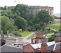
Nottingham, NG1 (Castle)
The Union Jack flutters in the breeze on a flagpole atop the 17th century ducal palace in the grounds of Nottingham Castle on the occasion of the Jubilee visit of Her Majesty Queen Elizabeth II, Prince William and Princess Catherine to the city.
Image: © David Hallam-Jones
Taken: 24 Jun 2012
0.01 miles
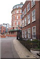
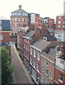
2
Down St James's Street
A view towards the dull tower blocks of Maid Marian Way from the former General Hospital site. Byron lived briefly in the handsome house on the left.
Image: © John Sutton
Taken: 30 Apr 2013
0.01 miles
3
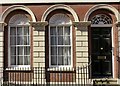
72 St James's Street, Nottingham ? detail
Ground floor windows and door. See http://www.geograph.org.uk/photo/6115475 for location.
Image: © Alan Murray-Rust
Taken: 8 Apr 2019
0.01 miles
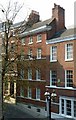
4
68 St James's Street, Nottingham
Town house, mid 18th century, now offices and flats, Listed Grade II.
Image: © Alan Murray-Rust
Taken: 8 Apr 2019
0.02 miles
5
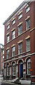
72 St James's Street, Nottingham
An elegant and unusually tall late Georgian town house, restored in the C20th for office use. It has decorative lintels to the windows and scallop shells on the ground floor. Grade II listed.
Image: © Stephen Richards
Taken: 17 Jun 2012
0.02 miles
6
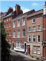
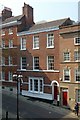
66-70 St James's Street, Nottingham
Three Georgian town houses on the largely unspoilt north side of the street. The nearest, quite badly proportioned, is early C18th, but is it, as Pevsner suggests, older behind? The mid- or late-C18th pair up the hill have more refined proportions. All grade II listed.
All offices now I think.
Image: © Stephen Richards
Taken: 17 Jun 2012
0.02 miles
7
70 St James's Street, Nottingham
Rather obscured behind the tree, this is a mid 18th century town house, later converted to offices and more recently to student bed-sit accommodation. Listed Grade II.
Image: © Alan Murray-Rust
Taken: 8 Apr 2019
0.02 miles
8
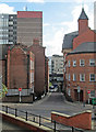
Nottingham NG1 (Castle Area)
The castle area end of St James' Street with a view of "The Roundhouse". Once part of the General Hospital complex, containing amongst other departments, the morgue, it now houses a ground floor pub/restaurant and apartments on the upper floors. Bryon, the poet, lived in the house behind the railings between 1778-79, a property that is still privately owned.
Image: © David Hallam-Jones
Taken: 24 Jun 2012
0.02 miles
9
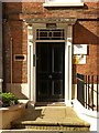
Castle House, 74 St James St, Nottingham
The front door. See http://www.geograph.org.uk/photo/6104375 for location.
Image: © Alan Murray-Rust
Taken: 24 Mar 2019
0.02 miles
10
Nottingham, NG1 (Castle Area)
This view of the higher end of St James' Street with "The Roundhouse" (the section of the former General Hospital complex that once contained the mortuary) gives an indication of why the Norman conquerers established the original Nottingham castle in this area. Between 1778-9 the poet Byron lived in the house situated on the right, behind the railings, at the junction with St James' Terrace. This photograph was taken from one of the upper floors of an NCP property lower down the street.
Image: © David Hallam-Jones
Taken: 24 Jun 2012
0.02 miles