IMAGES TAKEN NEAR TO
Hounds Gate, NOTTINGHAM, NG1 6BB
Introduction
This page details the photographs taken nearby to Hounds Gate, NG1 6BB by members of the Geograph project.
The Geograph project started in 2005 with the aim of publishing, organising and preserving representative images for every square kilometre of Great Britain, Ireland and the Isle of Man.

There are currently over 7.5m images from over14,400 individuals and you can help contribute to the project by visiting https://www.geograph.org.uk
Image Map
Images are licensed for reuse under creativecommons.org/licenses/by-sa/2.0
Notes
- Clicking on the map will re-center to the selected point.
- The higher the marker number, the further away the image location is from the centre of the postcode.
Image Listing (1899 Images Found)
Images are licensed for reuse under creativecommons.org/licenses/by-sa/2.0
Image
Details
Distance
1
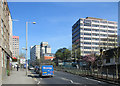
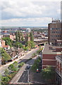
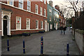
A spring morning in Maid Marian Way
In 1965 Arthur Ling, Professor of Town Planning at Nottingham University, described Maid Marian Way, which cut ruthlessly through the historic street pattern and led to the destruction of several significant buildings, as "one of the ugliest streets in Europe". The ancient Old Salutation Inn - parts of it restored out of all recognation - is on the right, dwarfed by the Travelodge, one of several wholly undistinguished tower blocks.
Image: © John Sutton
Taken: 22 Apr 2015
0.01 miles
2
The Gates of Nottingham (9)
"Houndsgate - the top end near the Castle.
Nottingham has some 15 streets incorporating the Norse-derived 'Gate', meaning a thoroughfare, not a barrier."
Next in series Image
Image: © Alan Murray-Rust
Taken: 11 Feb 2007
0.01 miles
3
Ye Olde Salutation Inn
Now without the For Sale sign. Image
Image: © David Lally
Taken: 8 Dec 2017
0.02 miles
4
Ye Old Salutation
A boozer with quite a few years behind it see Image but not the oldest in Nottingham!
Image: © Glyn Baker
Taken: 18 Apr 2015
0.02 miles
5
Nottingham, NG1 (Maid Marian Way)
A number of local landmarks are visible in this shot that leads the eye down Maid Marian Way (A6008) that is heading towards the Broadmarsh (previously Broad Marsh) section of the city, i.e. the area where upon the original Anglo-Saxon part of Snotengaham was established. (Snotengaham, i.e. HAM meaning 'home of' and SNOT referring to the leader of that early community).
Image: © David Hallam-Jones
Taken: 23 Jun 2012
0.02 miles
6
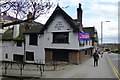
Ye Olde Salutation Inn
"The Sal"
One of the three candidates for the oldest pub in Nottingham. The other contenders being Image and Image
Image: © David Lally
Taken: 31 Mar 2017
0.03 miles
7
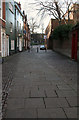
The Gates of Nottingham (4a)
Castle Gate looking towards the Castle.
Nottingham has nearly 20 streets incorporating the Norse-derived 'Gate', meaning a thoroughfare, not a barrier.
Next in series Image
Image: © Alan Murray-Rust
Taken: 11 Feb 2007
0.03 miles
8
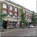
Park House, Friar Lane
A row of shops on the road leading from the Market Square to the Castle. On the left is Joe's, "a store full of Tintin" - books, pictures, T-shirts and the like.
Image: © John Sutton
Taken: 8 Sep 2017
0.03 miles
9
The Gates of Nottingham (4)
Castle Gate looking towards the Castle.
Nottingham has nearly 20 streets incorporating the Norse-derived 'Gate', meaning a thoroughfare, not a barrier.
Next in series Image
Image: © Alan Murray-Rust
Taken: 11 Feb 2007
0.03 miles
10
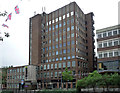
Castle Heights, Maid Marian Way, Nottingham
A mid-1960s office block by Harry Mein. Pevsner records that it funded his restoration of Newdigate House behind (Image]).
Image: © Stephen Richards
Taken: 17 Jun 2012
0.03 miles