IMAGES TAKEN NEAR TO
Maid Marian Way, NOTTINGHAM, NG1 6AB
Introduction
This page details the photographs taken nearby to Maid Marian Way, NG1 6AB by members of the Geograph project.
The Geograph project started in 2005 with the aim of publishing, organising and preserving representative images for every square kilometre of Great Britain, Ireland and the Isle of Man.

There are currently over 7.5m images from over14,400 individuals and you can help contribute to the project by visiting https://www.geograph.org.uk
Image Map
Images are licensed for reuse under creativecommons.org/licenses/by-sa/2.0
Notes
- Clicking on the map will re-center to the selected point.
- The higher the marker number, the further away the image location is from the centre of the postcode.
Image Listing (1582 Images Found)
Images are licensed for reuse under creativecommons.org/licenses/by-sa/2.0
Image
Details
Distance
1
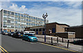
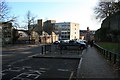
Castle College, Castle Road, Nottingham
By the City Architect's Department, 1956-61. The panels on the main block are faced in slate.
Image: © Stephen Richards
Taken: 17 Jun 2012
0.03 miles
2
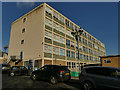
Nottingham College, Maid Marian Way site
See also Image
Image: © Stephen Craven
Taken: 18 Jan 2020
0.03 miles
3
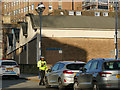
Watch out, here comes the warden
A traffic warden identifies a parking offender on Castle Road.
Image: © Stephen Craven
Taken: 18 Jan 2020
0.03 miles
4
Castle and College
A view towards the Castle Rock from the corner of Maid Marian Way and Collin Street. This branch of Central College was originally People's College. The poster shows the College's support for the Nottingham Panthers ice hockey team.
Image: © John Sutton
Taken: 26 May 2014
0.03 miles
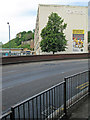
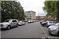
5
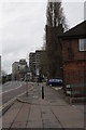
Castle Road, Nottingham
Looking downhill towards Castle Boulevard.
On the left is the People's College (now part of the multi-site Castle College) on the left the walls of Nottingham Castle.
Image: © David Lally
Taken: 7 Nov 2009
0.03 miles
7
Bench mark, Maid Marian Way
Looking north from the ramp leading to the service area of the Broad Marsh Centre. In the bottom right corner of the picture on the top of the concrete parapet can be found an example of a rivet-style bench mark. These are relatively rare; older examples often have an incised arrow pointing to the datum, but this one is almost anonymous.
Image: © Alan Murray-Rust
Taken: 17 May 2010
0.03 miles
8
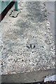
Benchmark on concrete wall beside ramp to Broad Marsh Centre
Ordnance Survey rivet benchmark described on the Bench Mark Database at http://www.bench-marks.org.uk/bm34405
Image: © Roger Templeman
Taken: 8 Apr 2012
0.03 miles
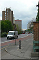
9
Maid Marian Way
St Nic's church tower is behind the trees. There is an OS benchmark Image on top of the low concrete wall seen on the right of the image.
Image: © Roger Templeman
Taken: 8 Apr 2012
0.03 miles
10
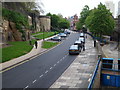
Nottingham - NG1 (Castle)
The view along Castle Road looking towards the main entrance to the castle, taken from a New College Nottingham (NCN) fire escape staircase.
Image: © David Hallam-Jones
Taken: 18 May 2012
0.03 miles