IMAGES TAKEN NEAR TO
Nightingale Crescent, NOTTINGHAM, NG16 6QG
Introduction
This page details the photographs taken nearby to Nightingale Crescent, NG16 6QG by members of the Geograph project.
The Geograph project started in 2005 with the aim of publishing, organising and preserving representative images for every square kilometre of Great Britain, Ireland and the Isle of Man.

There are currently over 7.5m images from over14,400 individuals and you can help contribute to the project by visiting https://www.geograph.org.uk
Image Map
Images are licensed for reuse under creativecommons.org/licenses/by-sa/2.0
Notes
- Clicking on the map will re-center to the selected point.
- The higher the marker number, the further away the image location is from the centre of the postcode.
Image Listing (16 Images Found)
Images are licensed for reuse under creativecommons.org/licenses/by-sa/2.0
Image
Details
Distance
1
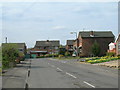
Period Dwellings at Annesley Lane End
Image: © Jonathan Clitheroe
Taken: 15 Jul 2022
0.07 miles
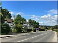
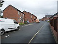
2
West end of Sherwood Way, Selston
Seen from Portland Road.
Image: © Richard Vince
Taken: 21 Apr 2018
0.12 miles
3
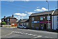
Ken's Newsagents and Off Licence, Selston
Oddly, this area of Selston is known as Skegness. It's a long way from the sea.
Image: © Neil Theasby
Taken: 13 Aug 2021
0.14 miles
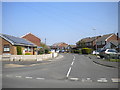
5
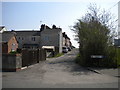
Recreation Street, Selston
Seen from Annesley Lane.
Image: © Richard Vince
Taken: 21 Apr 2018
0.17 miles
6
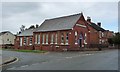
Church of Christ, Portland Road
Built as the Christians Meeting House in 1899. Now used by one of the 50 congregations in the Fellowship of Churches of Christ in Great Britain and Ireland.
Image: © Christine Johnstone
Taken: 19 Aug 2017
0.20 miles
7
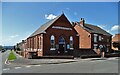
Christians Meeting House, A.D. 1899
At the junction of Portland Road and Victoria Road. This area was called New Portland when the church was built, but has now morphed into Selston. Now used by one of the 50 congregations in the Fellowship of Churches of Christ in Great Britain and Ireland.
Image: © Christine Johnstone
Taken: 19 Aug 2017
0.20 miles
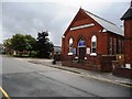
8
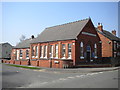
Christians Meeting House, Selston
On the corner of Victoria Road (left) and Portland Road. Dating from 1899, according to the inscription on the building.
Image: © Richard Vince
Taken: 21 Apr 2018
0.20 miles
9
Sovereign Gardens, off Portland Road
A newish infill development, between Victoria Street and Upper Mexborough Road.
Image: © Christine Johnstone
Taken: 19 Aug 2017
0.20 miles