IMAGES TAKEN NEAR TO
Brookhill Road, NOTTINGHAM, NG16 6NW
Introduction
This page details the photographs taken nearby to Brookhill Road, NG16 6NW by members of the Geograph project.
The Geograph project started in 2005 with the aim of publishing, organising and preserving representative images for every square kilometre of Great Britain, Ireland and the Isle of Man.

There are currently over 7.5m images from over14,400 individuals and you can help contribute to the project by visiting https://www.geograph.org.uk
Image Map
Images are licensed for reuse under creativecommons.org/licenses/by-sa/2.0
Notes
- Clicking on the map will re-center to the selected point.
- The higher the marker number, the further away the image location is from the centre of the postcode.
Image Listing (9 Images Found)
Images are licensed for reuse under creativecommons.org/licenses/by-sa/2.0
Image
Details
Distance
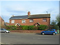
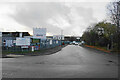
1

Brookhill Industrial Estate
This industrial estate is tacked onto the southern fringes of Pinxton.
Image: © Jonathan Clitheroe
Taken: 16 Feb 2013
0.01 miles
2
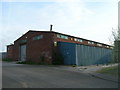
Industrial Unit, Brookhill Industrial Estate, Pinxton
Image: © JThomas
Taken: 28 Apr 2010
0.06 miles
3
Plymouth Avenue, Brookhill Industrial Estate, Pinxton
Image: © JThomas
Taken: 28 Apr 2010
0.10 miles
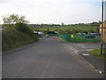
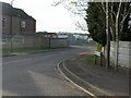
5
Brookhill Road
Access to Brookhill Industrial Estate.
Image: © Bill Boaden
Taken: 26 Nov 2021
0.16 miles
6
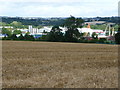
Industrial premises on Plymouth Road, Pinxton
On the flatter, north bank of the River Erewash, bordered by a railway line and the M1. The steeper south side is farmed.
Image: © Christine Johnstone
Taken: 19 Aug 2017
0.17 miles
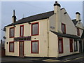
8
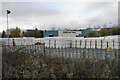
Reader Cement Products
The headquarters of a cement manufacturer.
Image: © Bill Boaden
Taken: 26 Nov 2021
0.23 miles