IMAGES TAKEN NEAR TO
Alfred Street, NOTTINGHAM, NG16 6NQ
Introduction
This page details the photographs taken nearby to Alfred Street, NG16 6NQ by members of the Geograph project.
The Geograph project started in 2005 with the aim of publishing, organising and preserving representative images for every square kilometre of Great Britain, Ireland and the Isle of Man.

There are currently over 7.5m images from over14,400 individuals and you can help contribute to the project by visiting https://www.geograph.org.uk
Image Map
Images are licensed for reuse under creativecommons.org/licenses/by-sa/2.0
Notes
- Clicking on the map will re-center to the selected point.
- The higher the marker number, the further away the image location is from the centre of the postcode.
Image Listing (15 Images Found)
Images are licensed for reuse under creativecommons.org/licenses/by-sa/2.0
Image
Details
Distance
1
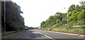
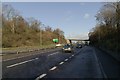
Approaching A38 lay by
Just west of M1 junction 28
Image: © John Firth
Taken: 9 Jul 2015
0.15 miles
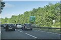
5
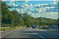
A38 near junction 28 of the M1 Motorway
Looking towards the Pinxton Lane bridge from the southbound lay-by.
Image: © Mark Anderson
Taken: 8 Dec 2018
0.17 miles
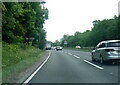
9

The M1 Motorway near Junction 28
Looking Northbound towards the junction with the A38.
Image: © Jonathan Clitheroe
Taken: 16 Feb 2013
0.21 miles
10
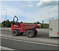
Dumptruck in the central area of the M1 motorway near Pinxton
Image: © Steve Fareham
Taken: 21 May 2014
0.22 miles