IMAGES TAKEN NEAR TO
Brookhill Lane, NOTTINGHAM, NG16 6JX
Introduction
This page details the photographs taken nearby to Brookhill Lane, NG16 6JX by members of the Geograph project.
The Geograph project started in 2005 with the aim of publishing, organising and preserving representative images for every square kilometre of Great Britain, Ireland and the Isle of Man.

There are currently over 7.5m images from over14,400 individuals and you can help contribute to the project by visiting https://www.geograph.org.uk
Image Map
Images are licensed for reuse under creativecommons.org/licenses/by-sa/2.0
Notes
- Clicking on the map will re-center to the selected point.
- The higher the marker number, the further away the image location is from the centre of the postcode.
Image Listing (26 Images Found)
Images are licensed for reuse under creativecommons.org/licenses/by-sa/2.0
Image
Details
Distance
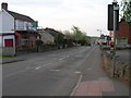
2
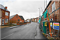
Town Street, Pinxton
The street has an assortment of mostly residential buildings, with new ones being built on the right.
Image: © Bill Boaden
Taken: 26 Nov 2021
0.07 miles
4
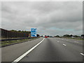
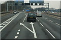
Approaching J28, M1
heading north through Derbyshire
Image: © Tom Courtney
Taken: 28 Aug 2005
0.07 miles
5
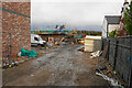
New housing off Town Street
There will be 8 three bedroom houses known as Sunnyside Mews.
Image: © Bill Boaden
Taken: 26 Nov 2021
0.08 miles
6
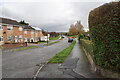
Woodfield Road
A residential road which runs parallel to Town Street and also the M1 motorway which you can hear.
Image: © Bill Boaden
Taken: 26 Nov 2021
0.09 miles
9
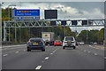
Bolsover District : M1 Motorway
The M1 Motorway between Junction 27 and Junction 28.
Image: © Lewis Clarke
Taken: 30 Sep 2018
0.12 miles