IMAGES TAKEN NEAR TO
Pinxton, NOTTINGHAM, NG16 6JB
Introduction
This page details the photographs taken nearby to NG16 6JB by members of the Geograph project.
The Geograph project started in 2005 with the aim of publishing, organising and preserving representative images for every square kilometre of Great Britain, Ireland and the Isle of Man.

There are currently over 7.5m images from over14,400 individuals and you can help contribute to the project by visiting https://www.geograph.org.uk
Image Map
Images are licensed for reuse under creativecommons.org/licenses/by-sa/2.0
Notes
- Clicking on the map will re-center to the selected point.
- The higher the marker number, the further away the image location is from the centre of the postcode.
Image Listing (11 Images Found)
Images are licensed for reuse under creativecommons.org/licenses/by-sa/2.0
Image
Details
Distance
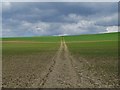
1
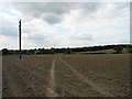
Arable land northwest of Franderground Farm
Image: © John Topping
Taken: 25 Jun 2013
0.16 miles
2
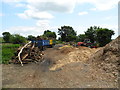
Wood Yard
West of Franderground Farm, on a dismantled railway.
Image: © John Topping
Taken: 25 Jun 2013
0.16 miles

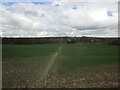
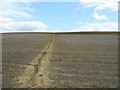
5
Dismantled Railway west of Franderground Farm
Image: © John Topping
Taken: 25 Jun 2013
0.20 miles
6
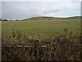
Towards Boar Hill, Kirkby in Ashfield
From the Pinxton road. The small blobs on the skyline are ramblers!
Image: © Katy Walters
Taken: 4 Dec 2005
0.22 miles
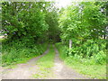
9
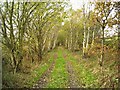
Former railway track (in autumn)
Former railway track to the north-west of Franderground Farm
Image: © Antony Dixon
Taken: 23 Nov 2011
0.24 miles
10
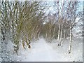
Former railway track (in winter)
Former railway track to the north-west of Franderground Farm
Image: © Antony Dixon
Taken: 5 Feb 2012
0.24 miles