IMAGES TAKEN NEAR TO
Cliff Lane Cottages, NOTTINGHAM, NG16 6HZ
Introduction
This page details the photographs taken nearby to Cliff Lane Cottages, NG16 6HZ by members of the Geograph project.
The Geograph project started in 2005 with the aim of publishing, organising and preserving representative images for every square kilometre of Great Britain, Ireland and the Isle of Man.

There are currently over 7.5m images from over14,400 individuals and you can help contribute to the project by visiting https://www.geograph.org.uk
Image Map
Images are licensed for reuse under creativecommons.org/licenses/by-sa/2.0
Notes
- Clicking on the map will re-center to the selected point.
- The higher the marker number, the further away the image location is from the centre of the postcode.
Image Listing (22 Images Found)
Images are licensed for reuse under creativecommons.org/licenses/by-sa/2.0
Image
Details
Distance
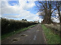
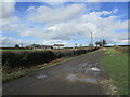
2

Cliff Lane
Heading south towards The Cliff, Cliff Farm and Kirkby Lane (B6019).
Image: © John Topping
Taken: 25 Jun 2013
0.11 miles

5
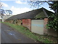
Barn at Cliff Farm
Stone built but extended and repaired in brick. The stonework is very heavily weathered.
Image: © Jonathan Thacker
Taken: 17 Mar 2023
0.14 miles
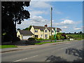
6
Cliff Farm
Side entrance off Cliff Lane.
Image: © John Topping
Taken: 25 Jun 2013
0.14 miles
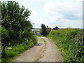
7
Cliff Lane
Cliff Lane is a public bridleway.
Kirkby Cliff Farm to the left.
Image: © Jonathan Thacker
Taken: 17 Mar 2023
0.14 miles
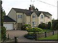
10
Cliff Farm Cottages
Off Kirkby Lane B6019.
Image: © John Topping
Taken: 25 Jun 2013
0.16 miles