IMAGES TAKEN NEAR TO
Wharf Road, NOTTINGHAM, NG16 6HA
Introduction
This page details the photographs taken nearby to Wharf Road, NG16 6HA by members of the Geograph project.
The Geograph project started in 2005 with the aim of publishing, organising and preserving representative images for every square kilometre of Great Britain, Ireland and the Isle of Man.

There are currently over 7.5m images from over14,400 individuals and you can help contribute to the project by visiting https://www.geograph.org.uk
Image Map
Images are licensed for reuse under creativecommons.org/licenses/by-sa/2.0
Notes
- Clicking on the map will re-center to the selected point.
- The higher the marker number, the further away the image location is from the centre of the postcode.
Image Listing (13 Images Found)
Images are licensed for reuse under creativecommons.org/licenses/by-sa/2.0
Image
Details
Distance
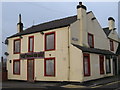
2
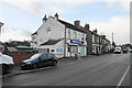
Town Street Store
A corner shop on Town Street.
Image: © Bill Boaden
Taken: 26 Nov 2021
0.13 miles
3
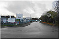
Reader Cement Products
The headquarters of a cement manufacturer.
Image: © Bill Boaden
Taken: 26 Nov 2021
0.14 miles
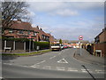
4
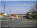
West end of Kirkby Lane, Pinxton
Seen from the east end of Wharf Road. The bridge ahead carries the M1.
Image: © Richard Vince
Taken: 6 Apr 2019
0.14 miles
5
Brookhill Road
Access to Brookhill Industrial Estate.
Image: © Bill Boaden
Taken: 26 Nov 2021
0.15 miles
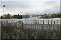
6
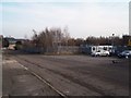
Brookhill Industrial Estate
This industrial estate is tacked onto the southern fringes of Pinxton.
Image: © Jonathan Clitheroe
Taken: 16 Feb 2013
0.16 miles
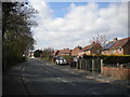
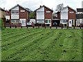
9
Woodfield Road, Pinxton
Off Town Street in the eastern part of the village.
Image: © Richard Vince
Taken: 6 Apr 2019
0.21 miles
10
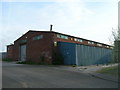
Industrial Unit, Brookhill Industrial Estate, Pinxton
Image: © JThomas
Taken: 28 Apr 2010
0.23 miles