IMAGES TAKEN NEAR TO
Launds Avenue, NOTTINGHAM, NG16 6GA
Introduction
This page details the photographs taken nearby to Launds Avenue, NG16 6GA by members of the Geograph project.
The Geograph project started in 2005 with the aim of publishing, organising and preserving representative images for every square kilometre of Great Britain, Ireland and the Isle of Man.

There are currently over 7.5m images from over14,400 individuals and you can help contribute to the project by visiting https://www.geograph.org.uk
Image Map
Images are licensed for reuse under creativecommons.org/licenses/by-sa/2.0
Notes
- Clicking on the map will re-center to the selected point.
- The higher the marker number, the further away the image location is from the centre of the postcode.
Image Listing (34 Images Found)
Images are licensed for reuse under creativecommons.org/licenses/by-sa/2.0
Image
Details
Distance
1
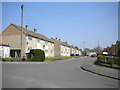
Launds Avenue, Selston Green
Seen from Desborough Road.
Image: © Richard Vince
Taken: 21 Apr 2018
0.05 miles
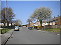
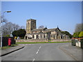
3
Desborough Road, Selston Green
Running south-east from Church Lane.
Image: © Christine Johnstone
Taken: 19 Aug 2017
0.08 miles
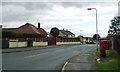
4
East end of St Helen's Church, Selston Green
Image: © Richard Vince
Taken: 21 Apr 2018
0.10 miles
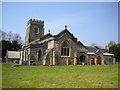
5
Church of St Helen, Selston
View from the east showing the new (2011) community hall extension on the right.
Image: © Alan Murray-Rust
Taken: 30 Nov 2014
0.10 miles
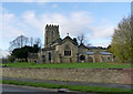
6
St Helen's Church, Selston Green
Seen from Desborough Road.
Image: © Richard Vince
Taken: 21 Apr 2018
0.10 miles
7
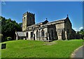
St Helen's Church, Selston Green
"The stone structure which now comprises St Helen’s church was started in the middle of the 12th century, and it seems to have been built in its entirety over a fairly short period of time. Several items within the church date from this early period of its history, including the Norman font and two carved stone slabs. It would seem that Selston was fairly wealthy at this stage, as in 1171 the parish was sending two shillings a year as a Pentecostal offering to Southwell, a high amount compared to other parishes in the area."
(Copied from Southwell and Nottingham Church History Project)
Image: © Neil Theasby
Taken: 13 Aug 2021
0.10 miles
8
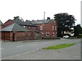
Beech Court Care Home, Church Lane, Selston
Caring for up to 23 people over the age of 55.
Image: © Christine Johnstone
Taken: 19 Aug 2017
0.11 miles
9
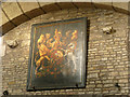
Church of St Helen, Selston
Royal coat of arms on the north wall of the nave. Dated to 1815 with the arms of George III.
Image: © Alan Murray-Rust
Taken: 30 Nov 2014
0.11 miles
10
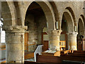
Church of St Helen, Selston
Late 12th century north aisle arcade with waterleaf and gargoyle decoration on the capitals.
Image: © Alan Murray-Rust
Taken: 30 Nov 2014
0.11 miles