IMAGES TAKEN NEAR TO
Lindley Street, NOTTINGHAM, NG16 6FT
Introduction
This page details the photographs taken nearby to Lindley Street, NG16 6FT by members of the Geograph project.
The Geograph project started in 2005 with the aim of publishing, organising and preserving representative images for every square kilometre of Great Britain, Ireland and the Isle of Man.

There are currently over 7.5m images from over14,400 individuals and you can help contribute to the project by visiting https://www.geograph.org.uk
Image Map
Images are licensed for reuse under creativecommons.org/licenses/by-sa/2.0
Notes
- Clicking on the map will re-center to the selected point.
- The higher the marker number, the further away the image location is from the centre of the postcode.
Image Listing (42 Images Found)
Images are licensed for reuse under creativecommons.org/licenses/by-sa/2.0
Image
Details
Distance
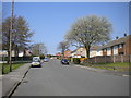
2
Launds Avenue, Selston Green
Seen from Desborough Road.
Image: © Richard Vince
Taken: 21 Apr 2018
0.08 miles

4
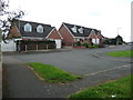
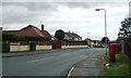
St Helen's Drive, Selston Green
A fairly new residential cul-de-sac behind the houses on the south side of Church Lane. The church is dedicated to St Helen.
Image: © Christine Johnstone
Taken: 19 Aug 2017
0.13 miles
5
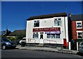
"The Old Post Office" on Alfreton Road, Selston
Now a cafe and takeaway.
Image: © Neil Theasby
Taken: 13 Aug 2021
0.13 miles

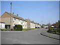
8
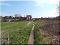
Desborough Road, Selston Green
Running south-east from Church Lane.
Image: © Christine Johnstone
Taken: 19 Aug 2017
0.14 miles
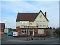
9
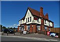
"The Bull and Butcher", Alfreton Road, Selston
Image: © Neil Theasby
Taken: 13 Aug 2021
0.14 miles