IMAGES TAKEN NEAR TO
Elmtree Avenue, NOTTINGHAM, NG16 6FR
Introduction
This page details the photographs taken nearby to Elmtree Avenue, NG16 6FR by members of the Geograph project.
The Geograph project started in 2005 with the aim of publishing, organising and preserving representative images for every square kilometre of Great Britain, Ireland and the Isle of Man.

There are currently over 7.5m images from over14,400 individuals and you can help contribute to the project by visiting https://www.geograph.org.uk
Image Map
Images are licensed for reuse under creativecommons.org/licenses/by-sa/2.0
Notes
- Clicking on the map will re-center to the selected point.
- The higher the marker number, the further away the image location is from the centre of the postcode.
Image Listing (8 Images Found)
Images are licensed for reuse under creativecommons.org/licenses/by-sa/2.0
Image
Details
Distance
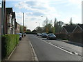
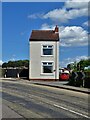

7
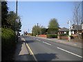
South east end of Common Side, Selston
Image: © Richard Vince
Taken: 21 Apr 2018
0.20 miles
8
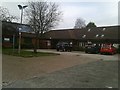
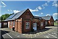
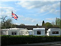
Surgery, Clinic and Community Centre in Selston
Pictured from the car park entrance on Nottingham Road.
Image: © Jonathan Clitheroe
Taken: 5 Jan 2019
0.25 miles