IMAGES TAKEN NEAR TO
Station Road, NOTTINGHAM, NG16 6FF
Introduction
This page details the photographs taken nearby to Station Road, NG16 6FF by members of the Geograph project.
The Geograph project started in 2005 with the aim of publishing, organising and preserving representative images for every square kilometre of Great Britain, Ireland and the Isle of Man.

There are currently over 7.5m images from over14,400 individuals and you can help contribute to the project by visiting https://www.geograph.org.uk
Image Map
Images are licensed for reuse under creativecommons.org/licenses/by-sa/2.0
Notes
- Clicking on the map will re-center to the selected point.
- The higher the marker number, the further away the image location is from the centre of the postcode.
Image Listing (11 Images Found)
Images are licensed for reuse under creativecommons.org/licenses/by-sa/2.0
Image
Details
Distance
1
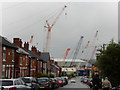
Station Road, Selston
Looking towards the level crossing where there was a passenger station until 1947. In the background are the unmissable premises of Delden Cranes.
Image: © Stephen McKay
Taken: 3 Sep 2016
0.04 miles
2
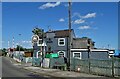
"The Railway Inn", Station Road, New Selston
Image: © Neil Theasby
Taken: 13 Aug 2021
0.07 miles
3
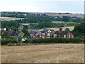
Houses on the east side of Station Road
Beyond, a railway passes under the M1 between junctions 27 and 28.
Image: © Christine Johnstone
Taken: 19 Aug 2017
0.08 miles
4
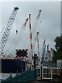
Pinxton Level Crossing
Pinxton Level Crossing, seen here from the front of the Railway Inn, is on the freight only line connecting Mansfield with the Erewash Valley route. The barriers are dwarfed by the premises of Delden Cranes.
Image: © Stephen McKay
Taken: 3 Sep 2016
0.10 miles
5
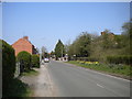
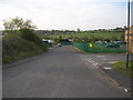
Station Road north of Selston
Presumably referring to the former Pinxton station, just across the boundary into Derbyshire, on the now freight only line from Pye Bridge to Kirkby.
Image: © Richard Vince
Taken: 21 Apr 2018
0.12 miles
6
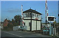
Pinxton - Signal Box
This signal box was dismantled in 2007, the box is now at Barrow hill roundhouse museum in Chesterfield in the final stages of restoration to working order.
Image: © Dave Bevis
Taken: 1 May 1984
0.13 miles
7
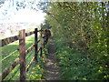
Public footpath to Station Road north east of Hall Green
Image: © Richard Vince
Taken: 21 Apr 2018
0.16 miles
8
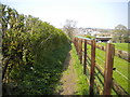
Public footpath to Pinxton north east of Hall Green
Image: © Richard Vince
Taken: 21 Apr 2018
0.17 miles
9
Plymouth Avenue, Brookhill Industrial Estate, Pinxton
Image: © JThomas
Taken: 28 Apr 2010
0.22 miles
10
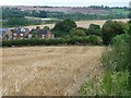
Field edge footpath to Station Road
Looking east towards the distant M1 [just south of Junction 28]. A buzzard is flying low across the stubble.
Image: © Christine Johnstone
Taken: 19 Aug 2017
0.23 miles