IMAGES TAKEN NEAR TO
Hobsic Lane, NOTTINGHAM, NG16 6FE
Introduction
This page details the photographs taken nearby to Hobsic Lane, NG16 6FE by members of the Geograph project.
The Geograph project started in 2005 with the aim of publishing, organising and preserving representative images for every square kilometre of Great Britain, Ireland and the Isle of Man.

There are currently over 7.5m images from over14,400 individuals and you can help contribute to the project by visiting https://www.geograph.org.uk
Image Map
Images are licensed for reuse under creativecommons.org/licenses/by-sa/2.0
Notes
- Clicking on the map will re-center to the selected point.
- The higher the marker number, the further away the image location is from the centre of the postcode.
Image Listing (13 Images Found)
Images are licensed for reuse under creativecommons.org/licenses/by-sa/2.0
Image
Details
Distance
1
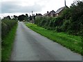
Houses in Hall Green
On the west side of Hobsic Lane. This area is a complex web of small settlements, linear development and suburban-style villages, presumably the result of coal mining in the 1800s.
Image: © Christine Johnstone
Taken: 19 Aug 2017
0.01 miles
2
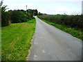
Hobsic Lane, Hall Green
Descending to a 118 metre spot height at the bend. Running north-west from Church Lane.
Image: © Christine Johnstone
Taken: 19 Aug 2017
0.03 miles
4
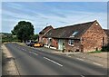
Hall Green Farm near Selston
Located on Church Lane. Just around the corner and down the hill is one of Nottinghamshire's finest historic pubs - The Horse and Jockey.
Image: © Jonathan Clitheroe
Taken: 17 Jun 2023
0.07 miles
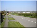
5
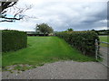
Public footpath to Station Road, near Hall Farm
Running north-east from Hobsic Lane.
Image: © Christine Johnstone
Taken: 19 Aug 2017
0.09 miles
6
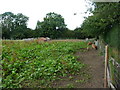
Piggery near Hall Green Farm
The inquisitive piglets were rootling along the footpath fence. With ginger coats, black spots and lop ears, are they the Oxford Sandy & Black breed?
Image: © Christine Johnstone
Taken: 19 Aug 2017
0.10 miles
7
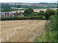
Field edge footpath to Station Road
Looking east towards the distant M1 [just south of Junction 28]. A buzzard is flying low across the stubble.
Image: © Christine Johnstone
Taken: 19 Aug 2017
0.12 miles
8
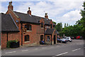
The Horse and Jockey, Selston
Atmospheric pub specialising in real ales on Church Lane.
Image: © Stephen McKay
Taken: 10 Jul 2016
0.14 miles
9
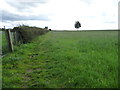
Public footpath from Church Lane to Stoney Lane
The lone tree is on a former field boundary, near the 140 metre local summit.
Image: © Christine Johnstone
Taken: 19 Aug 2017
0.14 miles
10
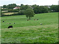
Cattle grazing south-east of Hall Green Farm
On the edge of Selston, looking east towards houses on Commonside.
Image: © Christine Johnstone
Taken: 19 Aug 2017
0.17 miles