IMAGES TAKEN NEAR TO
Homecroft Drive, NOTTINGHAM, NG16 6EZ
Introduction
This page details the photographs taken nearby to Homecroft Drive, NG16 6EZ by members of the Geograph project.
The Geograph project started in 2005 with the aim of publishing, organising and preserving representative images for every square kilometre of Great Britain, Ireland and the Isle of Man.

There are currently over 7.5m images from over14,400 individuals and you can help contribute to the project by visiting https://www.geograph.org.uk
Image Map
Images are licensed for reuse under creativecommons.org/licenses/by-sa/2.0
Notes
- Clicking on the map will re-center to the selected point.
- The higher the marker number, the further away the image location is from the centre of the postcode.
Image Listing (35 Images Found)
Images are licensed for reuse under creativecommons.org/licenses/by-sa/2.0
Image
Details
Distance
1
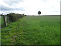
Public footpath from Church Lane to Stoney Lane
The lone tree is on a former field boundary, near the 140 metre local summit.
Image: © Christine Johnstone
Taken: 19 Aug 2017
0.16 miles
2
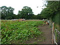
Piggery near Hall Green Farm
The inquisitive piglets were rootling along the footpath fence. With ginger coats, black spots and lop ears, are they the Oxford Sandy & Black breed?
Image: © Christine Johnstone
Taken: 19 Aug 2017
0.17 miles
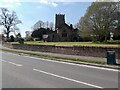
3
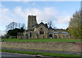
Church of St Helen, Selston
View from the east showing the new (2011) community hall extension on the right.
Image: © Alan Murray-Rust
Taken: 30 Nov 2014
0.17 miles
4
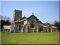
East end of St Helen's Church, Selston Green
Image: © Richard Vince
Taken: 21 Apr 2018
0.17 miles
6
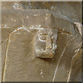
Church of St Helen, Selston
Gargoyle head on north aisle arcade capital.
Image: © Alan Murray-Rust
Taken: 30 Nov 2014
0.18 miles
7
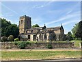
Church of St Helen in Selston
Pictured from the south east on Church Lane.
Image: © Jonathan Clitheroe
Taken: 17 Jun 2023
0.18 miles
8
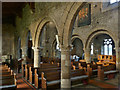
Church of St Helen, Selston
South aisle arcade, looking through into the nave.
Image: © Alan Murray-Rust
Taken: 30 Nov 2014
0.18 miles
9
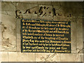
Church of St Helen, Selston
Detail of the tablet inside the canopy of the Willoughby monument. It includes details of William Willoughby's genealogy. It records his early death in 1630 at the age of just under 22, by which time he had already fathered four children.
Image: © Alan Murray-Rust
Taken: 30 Nov 2014
0.18 miles
10
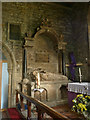
Church of St Helen, Selston
The Willoughby monument on the north wall of the chancel. See also http://www.geograph.org.uk/photo/4265931 .
Image: © Alan Murray-Rust
Taken: 30 Nov 2014
0.18 miles