IMAGES TAKEN NEAR TO
Alma Road, NOTTINGHAM, NG16 6BJ
Introduction
This page details the photographs taken nearby to Alma Road, NG16 6BJ by members of the Geograph project.
The Geograph project started in 2005 with the aim of publishing, organising and preserving representative images for every square kilometre of Great Britain, Ireland and the Isle of Man.

There are currently over 7.5m images from over14,400 individuals and you can help contribute to the project by visiting https://www.geograph.org.uk
Image Map
Images are licensed for reuse under creativecommons.org/licenses/by-sa/2.0
Notes
- Clicking on the map will re-center to the selected point.
- The higher the marker number, the further away the image location is from the centre of the postcode.
Image Listing (4 Images Found)
Images are licensed for reuse under creativecommons.org/licenses/by-sa/2.0
Image
Details
Distance
1
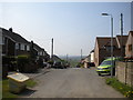
East end of Alma Road, Alma
Seen from its dead end.
Image: © Richard Vince
Taken: 21 Apr 2018
0.04 miles
2
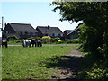
Notts - NG16 (Selston Area)
The commencement (or the end) of a section of the public footpath that runs between the closed end of Alma Road (cul-de-sac) and the Nottingham/Alfreton Road (B600) near to The White Lion pub. The Alma Road entrance/exit is behind the horse that is grazing in front of the tallest telegraph post.
Image: © David Hallam-Jones
Taken: 26 May 2012
0.06 miles
3
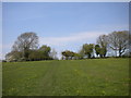
Footpath to Alma north of Bagthorpe
Making its just sufficiently perceptible way across the undulating fields.
Image: © Richard Vince
Taken: 21 Apr 2018
0.20 miles
4
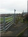
Footpath, Selston
Towards Allen's Green.
Image: © Katy Walters
Taken: 4 Dec 2005
0.22 miles