IMAGES TAKEN NEAR TO
Nottingham Road, NOTTINGHAM, NG16 6AD
Introduction
This page details the photographs taken nearby to Nottingham Road, NG16 6AD by members of the Geograph project.
The Geograph project started in 2005 with the aim of publishing, organising and preserving representative images for every square kilometre of Great Britain, Ireland and the Isle of Man.

There are currently over 7.5m images from over14,400 individuals and you can help contribute to the project by visiting https://www.geograph.org.uk
Image Map
Images are licensed for reuse under creativecommons.org/licenses/by-sa/2.0
Notes
- Clicking on the map will re-center to the selected point.
- The higher the marker number, the further away the image location is from the centre of the postcode.
Image Listing (13 Images Found)
Images are licensed for reuse under creativecommons.org/licenses/by-sa/2.0
Image
Details
Distance
1
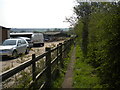
Footpath to Alma, Selston
Squeezing between the farms.
Image: © Richard Vince
Taken: 21 Apr 2018
0.12 miles
2
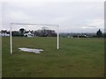
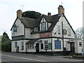
Playing field and pub, Selston
The White Lion, seen across a rather damp football pitch.
Image: © Katy Walters
Taken: 4 Dec 2005
0.16 miles
3
Selston Working Men's Club
Part of an area called Skegness on the 1:25k map - perhaps named after the Lincolnshire resort which is (was?) the traditional holiday destination for miners' families and many others in Nottinghamshire.
Thanks to correspondent Gavin who supplied this info to correct the original caption that wrongly stated this was the Miners' Welfare: This is Selston Working Men's Club, commonly known as The Jokers. The Welfare was situated on Mansfield Road in the village but is now called Selston Parish Hall.
Image: © Katy Walters
Taken: 4 Dec 2005
0.16 miles
4
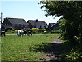
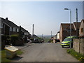
Notts - NG16 (Selston Area)
The commencement (or the end) of a section of the public footpath that runs between the closed end of Alma Road (cul-de-sac) and the Nottingham/Alfreton Road (B600) near to The White Lion pub. The Alma Road entrance/exit is behind the horse that is grazing in front of the tallest telegraph post.
Image: © David Hallam-Jones
Taken: 26 May 2012
0.17 miles
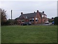
6
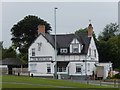
The White Lion, Selston Common
This refurbished pub is considerably smarter inside than it looks outside. See Image for a 2010 view.
Image: © Stephen McKay
Taken: 3 Sep 2016
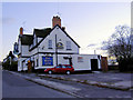
0.18 miles
7
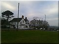
White Hart Public House at Selston Common
Pictured from the adjoining recreation ground.
Image: © Jonathan Clitheroe
Taken: 5 Jan 2019
0.18 miles
8
East end of Alma Road, Alma
Seen from its dead end.
Image: © Richard Vince
Taken: 21 Apr 2018
0.19 miles
9
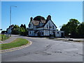
Notts - NG16 (Selston)
The White Lion, perhaps a former coaching inn, sits on the Nottingham/Alfreton Road (B600) overlooking a large recreation ground (i.e. behind the low railings) and is obliquely opposite the junction with Annesley Lane - a 'lane' that crosses the MI (North of Jct 27) a mile further on.
Image: © David Hallam-Jones
Taken: 26 May 2012
0.19 miles