IMAGES TAKEN NEAR TO
Providence Road, NOTTINGHAM, NG16 5LH
Introduction
This page details the photographs taken nearby to Providence Road, NG16 5LH by members of the Geograph project.
The Geograph project started in 2005 with the aim of publishing, organising and preserving representative images for every square kilometre of Great Britain, Ireland and the Isle of Man.

There are currently over 7.5m images from over14,400 individuals and you can help contribute to the project by visiting https://www.geograph.org.uk
Image Map
Images are licensed for reuse under creativecommons.org/licenses/by-sa/2.0
Notes
- Clicking on the map will re-center to the selected point.
- The higher the marker number, the further away the image location is from the centre of the postcode.
Image Listing (25 Images Found)
Images are licensed for reuse under creativecommons.org/licenses/by-sa/2.0
Image
Details
Distance
1
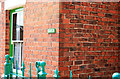
A House called Kevin
Pye Hill, Jacksdale.
Image: © David Lally
Taken: 26 Jul 2008
0.01 miles
5
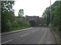
Railway bridges near Ironville (1)
This carries the main Nottingham to Sheffield line (opened in 1850 by the Midland Railway) over the B6016.
Image: © Jonathan Thacker
Taken: 30 May 2012
0.13 miles
6
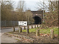
Pye Hill Road Railway Bridge
Pye Hill Road Railway bridge Nottinghamshire. Street furniture, transport, industry.
Image: © Martin Froggatt
Taken: 4 Jan 2020
0.13 miles
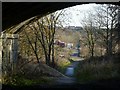
7
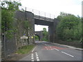
Railway bridges near Ironville (2)
This carries the Codnor Park Junction to Swanwick Colliery line of the Midland railway (opened in 1874) over the B6016. The line was extended a year later to Crich Junction and is now part of the preserved Midland Railway Centre.
Image: © Jonathan Thacker
Taken: 30 May 2012
0.16 miles
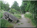
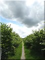
8

Path Near Pye Hill
Through woodland consisting mainly of young Birch.
Image: © David Lally
Taken: 26 Jul 2008
0.17 miles
9
Path to Jacksdale and Westwood
North of Pye Hill
Image: © Neil Theasby
Taken: 23 May 2016
0.20 miles
10
Footpath to Jacksdale
The straightness of the track suggests that it might originally have been a tramroad serving the local iron and coal industries.
Image: © Alan Murray-Rust
Taken: 30 Nov 2018
0.20 miles