IMAGES TAKEN NEAR TO
Shropshire Avenue, NOTTINGHAM, NG16 5JX
Introduction
This page details the photographs taken nearby to Shropshire Avenue, NG16 5JX by members of the Geograph project.
The Geograph project started in 2005 with the aim of publishing, organising and preserving representative images for every square kilometre of Great Britain, Ireland and the Isle of Man.

There are currently over 7.5m images from over14,400 individuals and you can help contribute to the project by visiting https://www.geograph.org.uk
Image Map
Images are licensed for reuse under creativecommons.org/licenses/by-sa/2.0
Notes
- Clicking on the map will re-center to the selected point.
- The higher the marker number, the further away the image location is from the centre of the postcode.
Image Listing (6 Images Found)
Images are licensed for reuse under creativecommons.org/licenses/by-sa/2.0
Image
Details
Distance
1
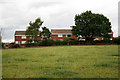
Houses on the edge of Jacksdale
They may actually officially be in Westwood.
Image: © David Lally
Taken: 31 Jul 2010
0.08 miles
2
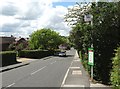
Bus stop on Wagstaff Lane, near Westdale Road
Image: © Neil Theasby
Taken: 23 May 2016
0.22 miles
4
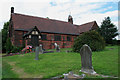
St Mary's, Westwood
Consecrated on September 9th, 1899.
Image: © David Lally
Taken: 31 Jul 2010
0.24 miles
5
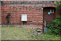
East wall of St Mary's, Westwood
With features of various ages. A water pump and gas meter and a half overgrown door.
Image: © David Lally
Taken: 31 Jul 2010
0.25 miles
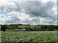
6
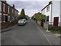
Isolated Street
This street is somewhat apart from the nearby Jacksdale and appears, at lest on the modern day map, to have a separate identity as Westwood.
Image: © Michael Patterson
Taken: 7 Apr 2006
0.25 miles