IMAGES TAKEN NEAR TO
Brinsley Hill, NOTTINGHAM, NG16 5HT
Introduction
This page details the photographs taken nearby to Brinsley Hill, NG16 5HT by members of the Geograph project.
The Geograph project started in 2005 with the aim of publishing, organising and preserving representative images for every square kilometre of Great Britain, Ireland and the Isle of Man.

There are currently over 7.5m images from over14,400 individuals and you can help contribute to the project by visiting https://www.geograph.org.uk
Image Map
Images are licensed for reuse under creativecommons.org/licenses/by-sa/2.0
Notes
- Clicking on the map will re-center to the selected point.
- The higher the marker number, the further away the image location is from the centre of the postcode.
Image Listing (18 Images Found)
Images are licensed for reuse under creativecommons.org/licenses/by-sa/2.0
Image
Details
Distance
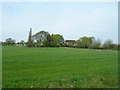
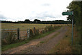
1
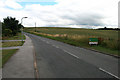
Brinsley Hill
Looking into the Borough of Broxtowe from Ashfield District.
Image: © David Lally
Taken: 31 Jul 2010
0.02 miles
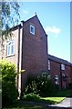
2
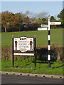
Village sign and fingerpost, Westwood
The village sign pays respect to the defunct coal mining industry of the area as well as the unknown soldier of the village war memorial http://www.geograph.org.uk/photo/4265907.
The fingerpost is a Notts C C modern cast-aluminium 'traditional' post with small annulus finial.
Image: © Alan Murray-Rust
Taken: 30 Nov 2014
0.06 miles

8
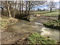
Yewtree Farm Ford
This ford on the Bagthorpe Brook is found opposite the entrance to Westwood Farm in Westwood.
Image: © John Walton
Taken: 1 Mar 2020
0.09 miles
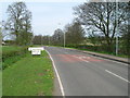
9
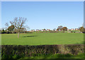
Near Westwood Farm
Looking up towards Jacksdale.
Image: © Alan Murray-Rust
Taken: 30 Nov 2014
0.09 miles
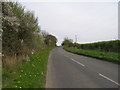
10
Sign for the path to Brinsley Gin
Branching off the track which is heading for a bridge over the River Erewash into Derbyshire.
Image: © David Lally
Taken: 31 Jul 2010
0.12 miles