IMAGES TAKEN NEAR TO
Wagstaff Lane, NOTTINGHAM, NG16 5HN
Introduction
This page details the photographs taken nearby to Wagstaff Lane, NG16 5HN by members of the Geograph project.
The Geograph project started in 2005 with the aim of publishing, organising and preserving representative images for every square kilometre of Great Britain, Ireland and the Isle of Man.

There are currently over 7.5m images from over14,400 individuals and you can help contribute to the project by visiting https://www.geograph.org.uk
Image Map
Images are licensed for reuse under creativecommons.org/licenses/by-sa/2.0
Notes
- Clicking on the map will re-center to the selected point.
- The higher the marker number, the further away the image location is from the centre of the postcode.
Image Listing (5 Images Found)
Images are licensed for reuse under creativecommons.org/licenses/by-sa/2.0
Image
Details
Distance
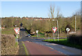
1
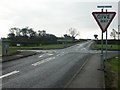
Crossroads, Barrows Green, Selston
Looking south.
Image: © Katy Walters
Taken: 4 Dec 2005
0.20 miles
2
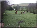
Llamas, Toadhole, Selston
Llamas being bred in the shadow of an old colliery spoil heap.
Image: © Katy Walters
Taken: 4 Dec 2005
0.20 miles
3
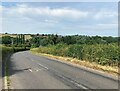
Looking Towards Selston from Barrow Hill
Image: © Jonathan Clitheroe
Taken: 17 Jun 2023
0.22 miles
4
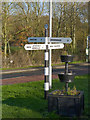
Fingerpost at Barrows Hill crossroads
Notts C C octagonal concrete post with slotted arms and octagonal cast-iron finial.
Image: © Alan Murray-Rust
Taken: 30 Nov 2014
0.24 miles
5
Barrows Hill crossroads
Looking north towards Selston.
Image: © Alan Murray-Rust
Taken: 30 Nov 2014
0.24 miles