IMAGES TAKEN NEAR TO
Lower Bagthorpe, NOTTINGHAM, NG16 5HF
Introduction
This page details the photographs taken nearby to Lower Bagthorpe, NG16 5HF by members of the Geograph project.
The Geograph project started in 2005 with the aim of publishing, organising and preserving representative images for every square kilometre of Great Britain, Ireland and the Isle of Man.

There are currently over 7.5m images from over14,400 individuals and you can help contribute to the project by visiting https://www.geograph.org.uk
Image Map
Images are licensed for reuse under creativecommons.org/licenses/by-sa/2.0
Notes
- Clicking on the map will re-center to the selected point.
- The higher the marker number, the further away the image location is from the centre of the postcode.
Image Listing (11 Images Found)
Images are licensed for reuse under creativecommons.org/licenses/by-sa/2.0
Image
Details
Distance
1
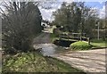
Bagthorpe Brook Ford
This ford on the Bagthorpe Brook is found in the entrance to Brookside Farm in Bagthorpe just opposite the Shepherds Rest public house. A video of the ford can be viewed at:
https://youtu.be/WMBtOe1oqeM
Image: © John Walton
Taken: 1 Mar 2020
0.10 miles
3
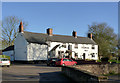
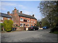
Shepherds Rest
Public house at Lower Bagthorpe.
Image: © Alan Murray-Rust
Taken: 30 Nov 2014
0.16 miles
4
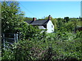
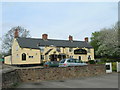
Notts - NG16 (Lower Bagthorpe)
The public footpath to and from the B600 (Annesley Road) where it joins Wansley Lane, Lower Bagthorpe between The Shepherd's Rest pub and Manor Farm. This is a view of the rear of the pub.
Image: © David Hallam-Jones
Taken: 26 May 2012
0.17 miles
5
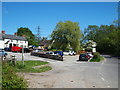
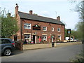
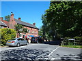
Notts - NG16 (Bagthorpe)
The Shepherd's Rest pub sitting on this bend on Wansley Lane, Lower Bagthorpe. Incidentally, the "thorp" part of the word Bagthorpe is said to be derived from the Danish word for a small village and Bagthorpe, it has been suggested, was founded by a Norseman named Baggi.
Image: © David Hallam-Jones
Taken: 26 May 2012
0.17 miles
6
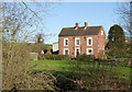
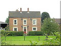
Manor Farmhouse, Bagthorpe
Late 18th century 3-bay farmhouse, with distinctive quoined window surrounds. Listed Grade II.
Image: © Alan Murray-Rust
Taken: 30 Nov 2014
0.22 miles
8
Notts - NG16 (Lower Bagthorpe)
The Dixies Arms pub is perhaps the most prominent feature of this junction where Church Lane meets School Road in Lower Bagthorpe. According to records the tithes of local people were previously “impropriated to the Lady Dixie, liyeing (sic) in the parish of Selston”. Thus it seems this pub, or the land upon which it was built, may once have belonged to this landowner.
Image: © David Hallam-Jones
Taken: 26 May 2012
0.22 miles