IMAGES TAKEN NEAR TO
Mainside Crescent, NOTTINGHAM, NG16 5FP
Introduction
This page details the photographs taken nearby to Mainside Crescent, NG16 5FP by members of the Geograph project.
The Geograph project started in 2005 with the aim of publishing, organising and preserving representative images for every square kilometre of Great Britain, Ireland and the Isle of Man.

There are currently over 7.5m images from over14,400 individuals and you can help contribute to the project by visiting https://www.geograph.org.uk
Image Map
Images are licensed for reuse under creativecommons.org/licenses/by-sa/2.0
Notes
- Clicking on the map will re-center to the selected point.
- The higher the marker number, the further away the image location is from the centre of the postcode.
Image Listing (9 Images Found)
Images are licensed for reuse under creativecommons.org/licenses/by-sa/2.0
Image
Details
Distance
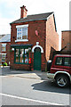
2

George V Postbox
Underwood Post Office.
Image: © David Lally
Taken: 26 Jul 2008
0.09 miles
4
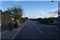
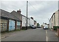
Main Road, Underwood
One of many roads named Main Road, or Main Street in this area. Each village seems to have one.
Image: © Malcolm Neal
Taken: 4 Nov 2021
0.16 miles
5
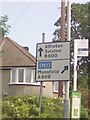
UK Direction Sign
UK Direction Sign on Alfreton Road in Underwood Nottingham Nottinghamshire.
Image: © gary
Taken: 15 Jul 2015
0.19 miles
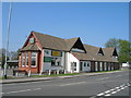
7
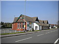
Underwood Miners Welfare
Situated between Alfreton Road (foreground) and Church Lane.
Image: © Richard Vince
Taken: 21 Apr 2018
0.24 miles
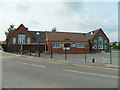
9
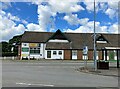
Underwood Miners Welfare Club
Social club and bus stop pictured from a busy road fork.
Image: © Jonathan Clitheroe
Taken: 5 Jul 2022
0.25 miles