IMAGES TAKEN NEAR TO
Mansfield Road, NOTTINGHAM, NG16 5FE
Introduction
This page details the photographs taken nearby to Mansfield Road, NG16 5FE by members of the Geograph project.
The Geograph project started in 2005 with the aim of publishing, organising and preserving representative images for every square kilometre of Great Britain, Ireland and the Isle of Man.

There are currently over 7.5m images from over14,400 individuals and you can help contribute to the project by visiting https://www.geograph.org.uk
Image Map
Images are licensed for reuse under creativecommons.org/licenses/by-sa/2.0
Notes
- Clicking on the map will re-center to the selected point.
- The higher the marker number, the further away the image location is from the centre of the postcode.
Image Listing (11 Images Found)
Images are licensed for reuse under creativecommons.org/licenses/by-sa/2.0
Image
Details
Distance
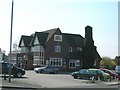
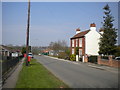
2
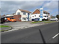
The Dog and Quayle Public House
Pictured from a junction off the A608 Road on a fine afternoon in early July.
Image: © Jonathan Clitheroe
Taken: 5 Jul 2022
0.07 miles
3
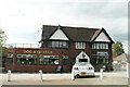
Flushed out of the Sandhills: Dog and Quayle
Change of name: see Sandhills Image
Image: © Chris
Taken: 13 May 2014
0.08 miles
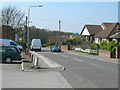
5
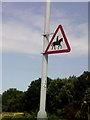
UK Accompanied Horses or Ponies Sign
UK Accompanied Horses or Ponies Sign on Alfreton Road Underwood Nottingham Nottinghamshire.
Image: © gary
Taken: 15 Jul 2015
0.11 miles
8
Looking over the Church wall and down Church Hill
Image: © Chris
Taken: 13 May 2014
0.23 miles
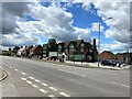
9
Church Lane, Underwood
Looking towards Bagthorpe.
Image: © Richard Vince
Taken: 21 Apr 2018
0.23 miles
10
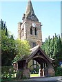
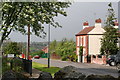
Underwood Church and Lychgate
The church and lychgate were designed by the Birmingham 'Gothic' architect, J. A. Chatwin in the style of the 14th century. They were erected in 1889 after being commissioned at a cost of £5000 by the 7th Earl Cowper who was a British Liberal politician and also served as Lord Lieutenant of Ireland between 1880 and 1882. The church dedicated to St Michael & All Angels had the clock installed in 1920 as a memorial to the local men who died in the First World War. The spire is visible from the surrounding countryside and is notable for being covered by oak shingles.
Image: © Garth Newton
Taken: 26 Aug 2005
0.24 miles