IMAGES TAKEN NEAR TO
Larch Close, NOTTINGHAM, NG16 5FA
Introduction
This page details the photographs taken nearby to Larch Close, NG16 5FA by members of the Geograph project.
The Geograph project started in 2005 with the aim of publishing, organising and preserving representative images for every square kilometre of Great Britain, Ireland and the Isle of Man.

There are currently over 7.5m images from over14,400 individuals and you can help contribute to the project by visiting https://www.geograph.org.uk
Image Map
Images are licensed for reuse under creativecommons.org/licenses/by-sa/2.0
Notes
- Clicking on the map will re-center to the selected point.
- The higher the marker number, the further away the image location is from the centre of the postcode.
Image Listing (13 Images Found)
Images are licensed for reuse under creativecommons.org/licenses/by-sa/2.0
Image
Details
Distance
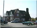
3
Flushed out of the Sandhills: Dog and Quayle
Change of name: see Sandhills Image
Image: © Chris
Taken: 13 May 2014
0.10 miles
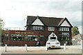
5
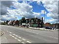
The Dog and Quayle Public House
Pictured from a junction off the A608 Road on a fine afternoon in early July.
Image: © Jonathan Clitheroe
Taken: 5 Jul 2022
0.11 miles
6
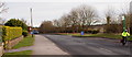
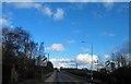
Shipton Hill, Felley NG16
With the village of Underwood a mile or so behind the photographer, this is the stretch of the A608 (Heanor-Annesley) Road with the entrance to Felley Priory and Felley Priory Garden Centre on the right. Behind the privet hedge on the left is Shipton Hill Farm. In the distant past Shipton Hill was written as "Chepynghyll" from the Old English word "scipen" meaning a cowshed.
Image: © David Hallam-Jones
Taken: 7 Feb 2013
0.21 miles
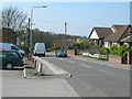
7
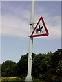
UK Accompanied Horses or Ponies Sign
UK Accompanied Horses or Ponies Sign on Alfreton Road Underwood Nottingham Nottinghamshire.
Image: © gary
Taken: 15 Jul 2015
0.23 miles
8
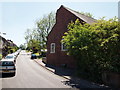
Notts - NG16 (Bagthorpe)
The view of the now defunct Bagthorpe Baptist Chapel from the Lower Bagthorpe end of Church Lane. It was built by a congregation of Primitive Methodists circa 1829 and then sold to a Baptist group in 1837. Apparently it has been unused for several years now but remains 'for sale'.
Image: © David Hallam-Jones
Taken: 26 May 2012
0.24 miles
9
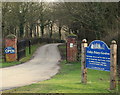
Felley Priory, Notts NG16
The entrance into the Felley Priory estate from the Shipton Hill area - on the A608 (Heanor-Annesley) Road.
Image: © David Hallam-Jones
Taken: 7 Feb 2013
0.24 miles
10
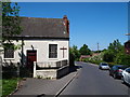
Notts - NG16 (Bagthorpe)
The view of the now defunct Bagthorpe Baptist Chapel from the St Michael and All Angels' Church end of Church Lane. It was built by a Primitive Methodists group circa 1829 and sold to a Baptist group in 1837. Apparently it has been unused for several years now but remains 'for sale'.
Image: © David Hallam-Jones
Taken: 26 May 2012
0.24 miles