IMAGES TAKEN NEAR TO
Old Chapel Lane, NOTTINGHAM, NG16 5ET
Introduction
This page details the photographs taken nearby to Old Chapel Lane, NG16 5ET by members of the Geograph project.
The Geograph project started in 2005 with the aim of publishing, organising and preserving representative images for every square kilometre of Great Britain, Ireland and the Isle of Man.

There are currently over 7.5m images from over14,400 individuals and you can help contribute to the project by visiting https://www.geograph.org.uk
Image Map
Images are licensed for reuse under creativecommons.org/licenses/by-sa/2.0
Notes
- Clicking on the map will re-center to the selected point.
- The higher the marker number, the further away the image location is from the centre of the postcode.
Image Listing (25 Images Found)
Images are licensed for reuse under creativecommons.org/licenses/by-sa/2.0
Image
Details
Distance
1
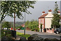
Looking over the Church wall and down Church Hill
Image: © Chris
Taken: 13 May 2014
0.11 miles
2
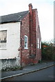
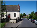
Bagthorpe Methodist Chapel 2014: the Lord hath left the building
See also Image
This shot shows the utilitarian end wall of the building, and also its size. It must have accommodated a large number of devout followers.
The cross has been removed, leaving an eerie imprint (right) on the wall.
The chapel was built by a Primitive Methodists group circa 1829 and sold to a Baptist group in 1837. Apparently it has been unused for several years. Image (2012) shows it still sporting the cross and looking quite smart, though already for sale.
Image: © Chris
Taken: 1 Nov 2014
0.12 miles
3
Bagthorpe Methodist Chapel 2014: the Lord hath left the building
...and taken his cross with him, leaving an eerie imprint (right) on the wall.
See also Image The chapel was built by a Primitive Methodists group circa 1829 and sold to a Baptist group in 1837. Apparently it has been unused for several years. Image (2012) shows it still sporting the cross and looking quite smart, though already for sale.
Image: © Chris
Taken: 1 Nov 2014
0.12 miles
4
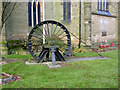
Pye Hill Colliery Memorial, Underwood Church
Dedicated in 1985. The plaque implies that the memorial is specifically to the Colliery rather than its workforce, and the churchyard seems an unusual location for it.
Image: © Alan Murray-Rust
Taken: 5 Dec 2014
0.12 miles
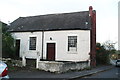
5
Notts - NG16 (Bagthorpe)
The view of the now defunct Bagthorpe Baptist Chapel from the St Michael and All Angels' Church end of Church Lane. It was built by a Primitive Methodists group circa 1829 and sold to a Baptist group in 1837. Apparently it has been unused for several years now but remains 'for sale'.
Image: © David Hallam-Jones
Taken: 26 May 2012
0.12 miles
6
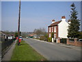
Church Lane, Underwood
Looking towards Bagthorpe.
Image: © Richard Vince
Taken: 21 Apr 2018
0.12 miles
7
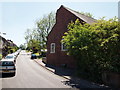
Notts - NG16 (Bagthorpe)
The view of the now defunct Bagthorpe Baptist Chapel from the Lower Bagthorpe end of Church Lane. It was built by a congregation of Primitive Methodists circa 1829 and then sold to a Baptist group in 1837. Apparently it has been unused for several years now but remains 'for sale'.
Image: © David Hallam-Jones
Taken: 26 May 2012
0.13 miles
8
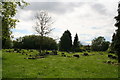
Underwood's large churchyard
Graves old and new, and plenty of room for more.
Image: © Chris
Taken: 13 May 2014
0.13 miles
9
Large churchyard, Underwood
Graves old and new, and plenty of room for more.
Image: © Chris
Taken: 13 May 2014
0.15 miles
10
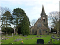
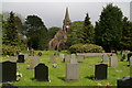
Church of St Michael and All Angels, Underwood
Viewed from the west. The church was built in 1890 for Earl Cowper, the main local landowner, designed by J A Chatwin. The church is in the 14th century Decorated style, with geometric tracery. Listed Grade II.
Image: © Alan Murray-Rust
Taken: 5 Dec 2014
0.15 miles