IMAGES TAKEN NEAR TO
Poppy Grange, NG16 5DW
Introduction
This page details the photographs taken nearby to Poppy Grange, NG16 5DW by members of the Geograph project.
The Geograph project started in 2005 with the aim of publishing, organising and preserving representative images for every square kilometre of Great Britain, Ireland and the Isle of Man.

There are currently over 7.5m images from over14,400 individuals and you can help contribute to the project by visiting https://www.geograph.org.uk
Image Map
Images are licensed for reuse under creativecommons.org/licenses/by-sa/2.0
Notes
- Clicking on the map will re-center to the selected point.
- The higher the marker number, the further away the image location is from the centre of the postcode.
Image Listing (1 Images Found)
Images are licensed for reuse under creativecommons.org/licenses/by-sa/2.0
Image
Details
Distance
1
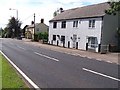
Brinsley/Underwood border
The building in the distance is the Yew Tree pub which is on Cordy Lane at Brinsley. A sign on the left at the side of the road indicates the start of the village which puts the other cottages on the right of the picture in Underwood. The whole area was surrounded at one time by mines on the Notts/Derbys Coalfield but they had all closed by the 1980s.
Image: © Garth Newton
Taken: 26 Aug 2005
0.13 miles