IMAGES TAKEN NEAR TO
Main Street, NOTTINGHAM, NG16 5BG
Introduction
This page details the photographs taken nearby to Main Street, NG16 5BG by members of the Geograph project.
The Geograph project started in 2005 with the aim of publishing, organising and preserving representative images for every square kilometre of Great Britain, Ireland and the Isle of Man.

There are currently over 7.5m images from over14,400 individuals and you can help contribute to the project by visiting https://www.geograph.org.uk
Image Map
Images are licensed for reuse under creativecommons.org/licenses/by-sa/2.0
Notes
- Clicking on the map will re-center to the selected point.
- The higher the marker number, the further away the image location is from the centre of the postcode.
Image Listing (21 Images Found)
Images are licensed for reuse under creativecommons.org/licenses/by-sa/2.0
Image
Details
Distance
1
Main Street
This is the edge of West Brinsley.
Image: © Malcolm Neal
Taken: 4 Nov 2021
0.01 miles
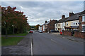
2
Main Street, New Brinsley
Looking towards Jacksdale.
Image: © Richard Vince
Taken: 21 Apr 2018
0.03 miles
4
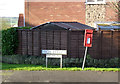
Postbox, High Street New Brinsley ref NG16 148
Standard EIIR lampbox on a rather dodgy post.
Note the 'this side only' appendage to the road name. This results from the later development of Clumber Avenue http://www.geograph.org.uk/photo/4265893 opposite. Some houses of this development were built facing onto High Street but addressed for Clumber Avenue.
Image: © Alan Murray-Rust
Taken: 30 Nov 2014
0.06 miles
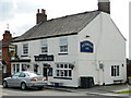
5
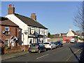
Durham Ox, New Brinsley
Serving what was originally one of many small mining communities in the area.
Image: © Alan Murray-Rust
Taken: 30 Nov 2014
0.06 miles
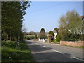
6

Clumber Avenue - This side only
See http://www.geograph.org.uk/photo/4265893 for an explanation.
Image: © Alan Murray-Rust
Taken: 30 Nov 2014
0.07 miles
7
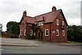
The Waggon and Horses
Recently closed pub in New Brinsley. Must have been open quite recently as it has been re-branded as a Greene King pub, so presumably was a Hardy Hanson house until the take over.
The sign has a Greene King crown on the pub sign mounting: Image
Image: © David Lally
Taken: 31 Jul 2010
0.07 miles
8
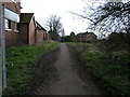
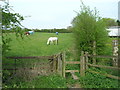
Busy Footpath
This footpath as the signs says leads to St James Church and Old Brinsley.
Image: © Michael Patterson
Taken: 7 Apr 2006
0.07 miles
9
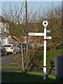
Fingerpost at New Brinsley
Notts C C modern cast-aluminium 'traditional' post with small annulus finial.
Image: © Alan Murray-Rust
Taken: 30 Nov 2014
0.08 miles