IMAGES TAKEN NEAR TO
Hobsic Close, NOTTINGHAM, NG16 5AX
Introduction
This page details the photographs taken nearby to Hobsic Close, NG16 5AX by members of the Geograph project.
The Geograph project started in 2005 with the aim of publishing, organising and preserving representative images for every square kilometre of Great Britain, Ireland and the Isle of Man.

There are currently over 7.5m images from over14,400 individuals and you can help contribute to the project by visiting https://www.geograph.org.uk
Image Map
Images are licensed for reuse under creativecommons.org/licenses/by-sa/2.0
Notes
- Clicking on the map will re-center to the selected point.
- The higher the marker number, the further away the image location is from the centre of the postcode.
Image Listing (4 Images Found)
Images are licensed for reuse under creativecommons.org/licenses/by-sa/2.0
Image
Details
Distance
1
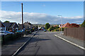
Hobsic Close
This is one of several cul-de-sac roads with a curve in them on the edge of New Brinsley.
Image: © Malcolm Neal
Taken: 4 Nov 2021
0.01 miles
2
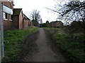
Busy Footpath
This footpath as the signs says leads to St James Church and Old Brinsley.
Image: © Michael Patterson
Taken: 7 Apr 2006
0.19 miles
3
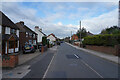
Broad Lane Brinsley
This is near the edge of Brinsley travelling towards Jacksdale.
Image: © Malcolm Neal
Taken: 4 Nov 2021
0.23 miles
4
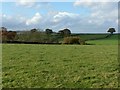
View towards Brinsley Moor
From the footpath between Brinsley Church and Hall Lane
Image: © Alan Murray-Rust
Taken: 12 Nov 2018
0.25 miles