IMAGES TAKEN NEAR TO
Daltons Close, NOTTINGHAM, NG16 4GP
Introduction
This page details the photographs taken nearby to Daltons Close, NG16 4GP by members of the Geograph project.
The Geograph project started in 2005 with the aim of publishing, organising and preserving representative images for every square kilometre of Great Britain, Ireland and the Isle of Man.

There are currently over 7.5m images from over14,400 individuals and you can help contribute to the project by visiting https://www.geograph.org.uk
Image Map
Images are licensed for reuse under creativecommons.org/licenses/by-sa/2.0
Notes
- Clicking on the map will re-center to the selected point.
- The higher the marker number, the further away the image location is from the centre of the postcode.
Image Listing (26 Images Found)
Images are licensed for reuse under creativecommons.org/licenses/by-sa/2.0
Image
Details
Distance
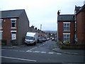
1
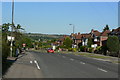
Cromford Road
This was the main A610 between Nottingham and Matlock before the current bypass was built.
Image: © Alan Murray-Rust
Taken: 16 Jun 2010
0.06 miles
2
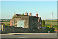
Waterworks building on Cromford Road
Marked on large scale maps as a pump house.
Image: © Alan Murray-Rust
Taken: 16 Jun 2010
0.07 miles
3
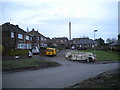
Homestead, Aldercar
A short residential cul de sac off Godkin Drive.
Image: © Richard Vince
Taken: 23 Jan 2016
0.09 miles
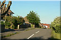
4
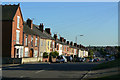
Upper Dunstead Road
Housing at Aldercar developed first at this end of the road before later development spread up from Langley Mill.
Image: © Alan Murray-Rust
Taken: 16 Jun 2010
0.10 miles
5
Ormonde Street, Aldercar
Seen from Upper Dunstead Road.
Image: © Richard Vince
Taken: 23 Jan 2016
0.12 miles
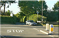
6
Service road alongside Cromford Road
Built when Cromford Road was the main route (A610) northwest from Nottingham. Since the construction of the Langley Mill bypass, the main carriageway itself sees relatively little traffic.
Image: © Alan Murray-Rust
Taken: 16 Jun 2010
0.12 miles
7
Aldercar Lane - Junction with Cromford Road
Image: © Alan Heardman
Taken: 29 Oct 2008
0.12 miles
8
End of Aldercar Lane
This is a long no through road to Stoneyford.
Image: © Alan Murray-Rust
Taken: 16 Jun 2010
0.12 miles
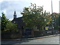
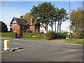
10
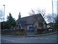
St John's Church, Aldercar
On the corner of Cromford Road (foreground) and Upper Dunstead Road.
Image: © Richard Vince
Taken: 23 Jan 2016
0.13 miles