IMAGES TAKEN NEAR TO
Cromford Road, NOTTINGHAM, NG16 4EX
Introduction
This page details the photographs taken nearby to Cromford Road, NG16 4EX by members of the Geograph project.
The Geograph project started in 2005 with the aim of publishing, organising and preserving representative images for every square kilometre of Great Britain, Ireland and the Isle of Man.

There are currently over 7.5m images from over14,400 individuals and you can help contribute to the project by visiting https://www.geograph.org.uk
Image Map
Images are licensed for reuse under creativecommons.org/licenses/by-sa/2.0
Notes
- Clicking on the map will re-center to the selected point.
- The higher the marker number, the further away the image location is from the centre of the postcode.
Image Listing (11 Images Found)
Images are licensed for reuse under creativecommons.org/licenses/by-sa/2.0
Image
Details
Distance
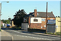
1

Sir Charles Napier
Inn sign of the now closed pub on Cromford Road. This could have been named after either General Sir Charles James Napier or his cousin Admiral Sir Charles John Napier. The sign certainly shows a gentleman in naval uniform, so one has to assume the latter.
Image: © Alan Murray-Rust
Taken: 16 Jun 2010
0.11 miles
2
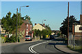
Cromford Road
The sharp bend at Aldercar, looking towards Langley Mill. This was the main A610 before the construction of the Langley Mill Bypass.
Image: © Alan Murray-Rust
Taken: 16 Jun 2010
0.11 miles
3
Sir Charles Napier
One more closed pub, on Cromford Road in Aldercar.
See http://www.geograph.org.uk/photo/1921154 for the likely origin of the name.
Image: © Alan Murray-Rust
Taken: 16 Jun 2010
0.11 miles
5
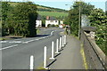
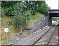
Cromford Road
The bridge over the Erewash Valley railway line.
Image: © Alan Murray-Rust
Taken: 16 Jun 2010
0.17 miles
8
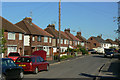
Plumptre Road
1930s housing at the northern end of Aldercar.
Image: © Alan Murray-Rust
Taken: 16 Jun 2010
0.21 miles
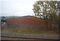
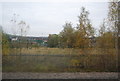
9
Railway north of Langley Mill Station
The site of a former goods yard is now overgrown with birch trees.
Image: © Jonathan Thacker
Taken: 29 Oct 2023
0.23 miles
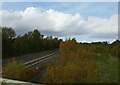
10
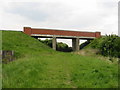
Wot no canal?
This bridge carried the A610 bypass over a mineral railway, now closed. The Friends of the Cromford Canal hope that it will be the route for a restored canal (the original route having been severed by the A610). http://cromfordcanal.info
Image: © S Parish
Taken: 18 May 2005
0.24 miles