IMAGES TAKEN NEAR TO
Willow Close, NOTTINGHAM, NG16 4EA
Introduction
This page details the photographs taken nearby to Willow Close, NG16 4EA by members of the Geograph project.
The Geograph project started in 2005 with the aim of publishing, organising and preserving representative images for every square kilometre of Great Britain, Ireland and the Isle of Man.

There are currently over 7.5m images from over14,400 individuals and you can help contribute to the project by visiting https://www.geograph.org.uk
Image Map
Images are licensed for reuse under creativecommons.org/licenses/by-sa/2.0
Notes
- Clicking on the map will re-center to the selected point.
- The higher the marker number, the further away the image location is from the centre of the postcode.
Image Listing (26 Images Found)
Images are licensed for reuse under creativecommons.org/licenses/by-sa/2.0
Image
Details
Distance
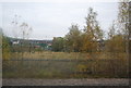
3
Railway north of Langley Mill Station
The site of a former goods yard is now overgrown with birch trees.
Image: © Jonathan Thacker
Taken: 29 Oct 2023
0.12 miles
4
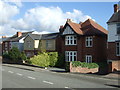
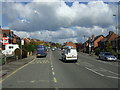
Houses on Upper Dunstead Road, Langley Mill
Image: © JThomas
Taken: 20 Oct 2015
0.13 miles
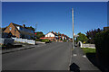
5
Bus stop on Upper Dunstead Road
Looking north.
Image: © JThomas
Taken: 20 Oct 2015
0.14 miles
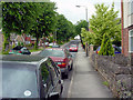
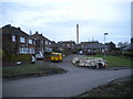
6
Lower Dunstead Road
This road runs up the hill in Langley Mill ending at a cross road junction with Aldercar Lane and Cromford Road.
Image: © Malcolm Neal
Taken: 21 Oct 2021
0.14 miles
7
Lower Dunstead Road Langley Mill
Looking Northwards. Pic by Tom
Image: © Q
Taken: 13 Jun 2005
0.15 miles
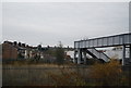
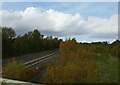
9
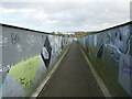
Footbridge over the railway, Langley Mill
Image: © Jonathan Thacker
Taken: 29 Oct 2023
0.18 miles
10
Homestead, Aldercar
A short residential cul de sac off Godkin Drive.
Image: © Richard Vince
Taken: 23 Jan 2016
0.20 miles