IMAGES TAKEN NEAR TO
Eastview Terrace, NOTTINGHAM, NG16 4DF
Introduction
This page details the photographs taken nearby to Eastview Terrace, NG16 4DF by members of the Geograph project.
The Geograph project started in 2005 with the aim of publishing, organising and preserving representative images for every square kilometre of Great Britain, Ireland and the Isle of Man.

There are currently over 7.5m images from over14,400 individuals and you can help contribute to the project by visiting https://www.geograph.org.uk
Image Map
Images are licensed for reuse under creativecommons.org/licenses/by-sa/2.0
Notes
- Clicking on the map will re-center to the selected point.
- The higher the marker number, the further away the image location is from the centre of the postcode.
Image Listing (18 Images Found)
Images are licensed for reuse under creativecommons.org/licenses/by-sa/2.0
Image
Details
Distance
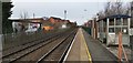
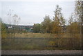
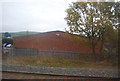
1
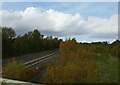
Railway north of Langley Mill Station
The site of a former goods yard is now overgrown with birch trees.
Image: © Jonathan Thacker
Taken: 29 Oct 2023
0.08 miles
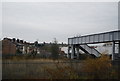
4
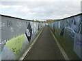
Footbridge over the railway, Langley Mill
Image: © Jonathan Thacker
Taken: 29 Oct 2023
0.13 miles
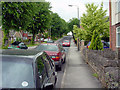
5
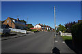
Lower Dunstead Road
This road runs up the hill in Langley Mill ending at a cross road junction with Aldercar Lane and Cromford Road.
Image: © Malcolm Neal
Taken: 21 Oct 2021
0.14 miles
6
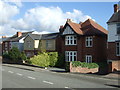
Houses on Upper Dunstead Road, Langley Mill
Image: © JThomas
Taken: 20 Oct 2015
0.14 miles
8
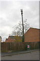
A tree with roosting birds by coms mast, North Street
What may look like leaves are in fact birds
Image: © Roger Templeman
Taken: 27 Nov 2017
0.16 miles
9
Lower Dunstead Road Langley Mill
Looking Northwards. Pic by Tom
Image: © Q
Taken: 13 Jun 2005
0.17 miles