IMAGES TAKEN NEAR TO
Willey Lane, NOTTINGHAM, NG16 3QW
Introduction
This page details the photographs taken nearby to Willey Lane, NG16 3QW by members of the Geograph project.
The Geograph project started in 2005 with the aim of publishing, organising and preserving representative images for every square kilometre of Great Britain, Ireland and the Isle of Man.

There are currently over 7.5m images from over14,400 individuals and you can help contribute to the project by visiting https://www.geograph.org.uk
Image Map
Images are licensed for reuse under creativecommons.org/licenses/by-sa/2.0
Notes
- Clicking on the map will re-center to the selected point.
- The higher the marker number, the further away the image location is from the centre of the postcode.
Image Listing (10 Images Found)
Images are licensed for reuse under creativecommons.org/licenses/by-sa/2.0
Image
Details
Distance
1
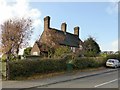
Hunts Hill Cottages
Dated 1877, these cottages are one of a number of farmhouses and estate cottages designed by E. W. Godwin for Earl Cowper in 1872-1878. Listed Grade II.
Image: © Alan Murray-Rust
Taken: 12 Nov 2018
0.01 miles
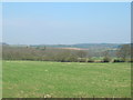
2
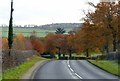
B600 near Oaks Farm
Rich autumn gold from the hedgerow trees.
Image: © Alan Murray-Rust
Taken: 12 Nov 2018
0.07 miles
4
Private drive to Lamb Close House
Lamb Close House was originally a farmhouse purchased by Sir Matthew Lamb in 1793. Before being nationalised mines in the area were owned by the Barber and Walker families and the Barber family lived at Lamb Close House. It was not unusual for mine owners to create their own estates.
Image: © Garth Newton
Taken: 31 Aug 2005
0.17 miles
6
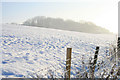
Unnamed plantation
At least it is not nammed on the OS maps, I'm sure someone must call it something.
Image: © David Lally
Taken: 5 Dec 2010
0.21 miles
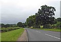
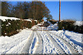
8
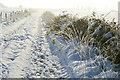
Frost and snow on a farm track
The track runs approximately south from Willey Wood Farm to Coneygrey Farm.
Image: © David Lally
Taken: 5 Dec 2010
0.23 miles
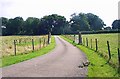
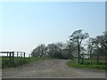
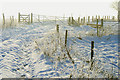
9
Gated track
By Willey Wood Farm, the track appears to have been well cleared for access to the farm from the nearby B600. The entrance from there can be seen here Image
Image: © David Lally
Taken: 5 Dec 2010
0.24 miles
10
Gate on the track south from Willey Wood Farm
Heading toward Coneygrey Farm.
Image: © David Lally
Taken: 5 Dec 2010
0.24 miles