IMAGES TAKEN NEAR TO
Greenhills Road, NOTTINGHAM, NG16 3FU
Introduction
This page details the photographs taken nearby to Greenhills Road, NG16 3FU by members of the Geograph project.
The Geograph project started in 2005 with the aim of publishing, organising and preserving representative images for every square kilometre of Great Britain, Ireland and the Isle of Man.

There are currently over 7.5m images from over14,400 individuals and you can help contribute to the project by visiting https://www.geograph.org.uk
Image Map
Images are licensed for reuse under creativecommons.org/licenses/by-sa/2.0
Notes
- Clicking on the map will re-center to the selected point.
- The higher the marker number, the further away the image location is from the centre of the postcode.
Image Listing (51 Images Found)
Images are licensed for reuse under creativecommons.org/licenses/by-sa/2.0
Image
Details
Distance
1
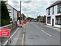
Roadworks on Greenhill Road
Similar works were blighting Eastwood town centre as well on this day.
Image: © Jonathan Clitheroe
Taken: 14 Jun 2022
0.03 miles
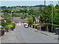
3
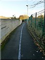
The thin blue line
The footpath connects Atherfield Gardens with Garden Road. The blue line is not a carriageway separation, but can be found throughout Eastwood designating the D H Lawrence Heritage Trail.
Image: © Alan Murray-Rust
Taken: 12 Nov 2018
0.12 miles
4
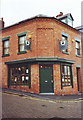
D H Lawrence Birthplace Museum, Eastwood, Notts
A small, but fascinating museum even for non fans.
Image: © nick macneill
Taken: 24 Nov 1998
0.15 miles
5
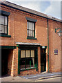
D H Lawrence Birthplace, Eastwood
D H Lawrence was born in the bedroom immediately above the shop window; there is now an adjacent Birthplace Museum.
Image: © John G Hill
Taken: 14 Sep 2007
0.15 miles
6
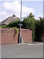
UK Turn Right Sign
UK Turn Right Sign On Princes St Eastwood Nottingham Nottinghamshire.
Image: © gary
Taken: 15 Jul 2019
0.16 miles
7
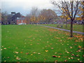
Mansfield Road Recreation Centre
With the children's playground and Durban House at the bottom.
Image: © Trevor Rickard
Taken: 14 Nov 2009
0.17 miles
8
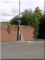
UK Turn Right Sign
UK Turn Right Sign On Princes St Eastwood Nottingham Nottinghamshire.
Image: © gary
Taken: 12 Aug 2019
0.17 miles
9
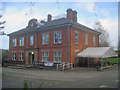
Durban House
Large house situated on Mansfield Road, which together with Image a short distance away makes up an interesting exhibition of the life and times of D H Lawrence. The building itself was built in 1896 as the administration offices for Barber Walker & Co, who ran the coal mines in the area until nationalisation in 1947.
http://www.lawrenceseastwood.co.uk/durbanhouse.htm
Image
Image: © Trevor Rickard
Taken: 14 Nov 2009
0.18 miles
10
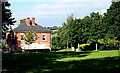
Eastwood, Lawrence Heritage Museum - NG16
A view of one side of Durban House from the Mansfield Road Recreation Ground. This museum is situated on Mansfield Road on the corner of its junction with Greenhills Road. Durban House was built in 1896 for the Barber Walker mining company. It once housed the wages office for Brinsley Colliery, the colliery where D.H. Lawrence's father worked and it was here that the young D.H. (”Bert”) Lawrence would sometimes be sent to collect his father’s wage packet. Later on the house was turned into a mining institute, with a concert hall, billiard table and a library, before being converted into flats. More recently the house was left empty for several years, whereas nowadays it holds many of the Lawrence historical collections.
Image: © David Hallam-Jones
Taken: 8 Sep 2012
0.18 miles