IMAGES TAKEN NEAR TO
Robey Drive, NOTTINGHAM, NG16 3DP
Introduction
This page details the photographs taken nearby to Robey Drive, NG16 3DP by members of the Geograph project.
The Geograph project started in 2005 with the aim of publishing, organising and preserving representative images for every square kilometre of Great Britain, Ireland and the Isle of Man.

There are currently over 7.5m images from over14,400 individuals and you can help contribute to the project by visiting https://www.geograph.org.uk
Image Map (Loading...)


Getting Data...Please wait
Leaflet Map data © OpenStreetMap
Images are licensed for reuse under creativecommons.org/licenses/by-sa/2.0
Notes
- Clicking on the map will re-center to the selected point.
- The higher the marker number, the further away the image location is from the centre of the postcode.
Image Listing (16 Images Found)
Images are licensed for reuse under creativecommons.org/licenses/by-sa/2.0
Image
Details
Distance
1
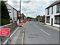
Roadworks on Greenhill Road
Similar works were blighting Eastwood town centre as well on this day.
Image: © Jonathan Clitheroe
Taken: 14 Jun 2022
0.07 miles
2
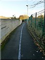
The thin blue line
The footpath connects Atherfield Gardens with Garden Road. The blue line is not a carriageway separation, but can be found throughout Eastwood designating the D H Lawrence Heritage Trail.
Image: © Alan Murray-Rust
Taken: 12 Nov 2018
0.16 miles
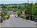
4
Bridleway off Mansfield Road, Eastwood
One of several tracks leading to Coneygrey Farm.
Image: © Alan Murray-Rust
Taken: 12 Nov 2018
0.21 miles
5
Eastwood, Gdn Rd - NG16
This Victorian end-of-terrace property - once known as No.57, The Breach but now known as 28, Garden Road - is where D.H.Lawrence lived as a toddler between 1887-91. He had contracted tuberculosis as an infant and had not been expected to live, thus this was his second home. He lived here with his father (a butty man, a self-employed foreman miner), his mother, two brothers and a sister. It is also the setting of the Morrel's house in his novel "Sons and Lovers". The ground floor is a private museum and the upper floors are a holiday rental property. Greenhills Road lies in the distance.
Image: © David Hallam-Jones
Taken: 7 Sep 2012
0.21 miles
6
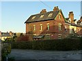
28 Garden Road, Eastwood
Although basically identical to other houses in this neighbourhood, known as The Breach, this particular house is Listed Grade II. This is because it is one of the addresses at which the family of D H Lawrence lived, between 1887 and 1891. The house is now a study centre and has been furnished in contemporary style.
Image: © Alan Murray-Rust
Taken: 12 Nov 2018
0.21 miles
7
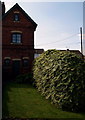
Eastwood, Gdn St - NG16
The rear of a Victorian end-of-terrace property once known as No.57, The Breach but now known as 28, Garden Road. This is where D.H.Lawrence lived as a toddler between 1887-91. He had contracted tuberculosis as an infant and had not been expected to live, thus this was his second home. He lived here with his father (a self-employed miner), his mother, two brothers and a sister. The family paid sixpence extra per week to live here because of its larger gardens and end of terrace position. It provided the setting for the Morrel's house in his novel "Sons and Lovers". The ground floor is a private museum and the upper floors are a holiday rental property.
Image: © David Hallam-Jones
Taken: 7 Sep 2012
0.21 miles
8
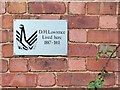
Plaque at 28 Garden Road, Eastwood
See http://www.geograph.org.uk/photo/5976056 for location.
Image: © Alan Murray-Rust
Taken: 12 Nov 2018
0.21 miles
9
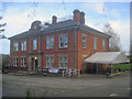
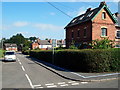
Durban House
Large house situated on Mansfield Road, which together with Image a short distance away makes up an interesting exhibition of the life and times of D H Lawrence. The building itself was built in 1896 as the administration offices for Barber Walker & Co, who ran the coal mines in the area until nationalisation in 1947.
http://www.lawrenceseastwood.co.uk/durbanhouse.htm
Image
Image: © Trevor Rickard
Taken: 14 Nov 2009
0.22 miles
10
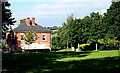
Eastwood, Lawrence Heritage Museum - NG16
A view of one side of Durban House from the Mansfield Road Recreation Ground. This museum is situated on Mansfield Road on the corner of its junction with Greenhills Road. Durban House was built in 1896 for the Barber Walker mining company. It once housed the wages office for Brinsley Colliery, the colliery where D.H. Lawrence's father worked and it was here that the young D.H. (”Bert”) Lawrence would sometimes be sent to collect his father’s wage packet. Later on the house was turned into a mining institute, with a concert hall, billiard table and a library, before being converted into flats. More recently the house was left empty for several years, whereas nowadays it holds many of the Lawrence historical collections.
Image: © David Hallam-Jones
Taken: 8 Sep 2012
0.22 miles