IMAGES TAKEN NEAR TO
Albert Street, NOTTINGHAM, NG16 3BA
Introduction
This page details the photographs taken nearby to Albert Street, NG16 3BA by members of the Geograph project.
The Geograph project started in 2005 with the aim of publishing, organising and preserving representative images for every square kilometre of Great Britain, Ireland and the Isle of Man.

There are currently over 7.5m images from over14,400 individuals and you can help contribute to the project by visiting https://www.geograph.org.uk
Image Map
Images are licensed for reuse under creativecommons.org/licenses/by-sa/2.0
Notes
- Clicking on the map will re-center to the selected point.
- The higher the marker number, the further away the image location is from the centre of the postcode.
Image Listing (106 Images Found)
Images are licensed for reuse under creativecommons.org/licenses/by-sa/2.0
Image
Details
Distance
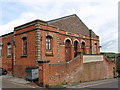
2
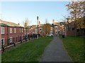
Eastwood, Albert St Elongation
A former corner shop, now providing residential accommodation, sits on an Albert Street corner looking along a service road between several rows of social housing units for older people. D.H. Lawrence's Birthplace Museum is on Victoria Street at the end of this road.
Image: © David Hallam-Jones
Taken: 7 Sep 2012
0.02 miles
3
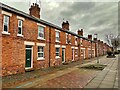
Princes Street - 2
Looking east from the junction with Victoria Street. The 19th century saw a huge increase in the amount of coal produced by this region. This led to a steady influx of mine workers and their families, attracted by the dangerous but well-paid work. Eastwood had to expand to meet the need. Barber Walker & Co built quadrangles of houses on this hillside to house the workforce at their mines just to the north.
Image
Image: © Trevor Rickard
Taken: 14 Nov 2009
0.02 miles
4
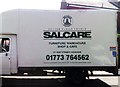
Salcare Van
Salcare Van On Albert Street Eastwood Nottingham Nottinghamshire.
Image: © gary
Taken: 10 Aug 2019
0.03 miles
5
Scargill Walk, Eastwood
Despite the mining associations locally, the name Scargill is unconnected with the 20th century miners' leader. There was a Scargill Street on this site before 1875.
Worth observing is how little difference there is between the late 20th development on the left and the mid 19th century terraced houses at the end of the walk.
Image: © Alan Murray-Rust
Taken: 12 Nov 2018
0.04 miles
6
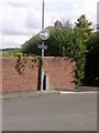
UK Turn Right Sign
UK Turn Right Sign On Princes St Eastwood Nottingham Nottinghamshire.
Image: © gary
Taken: 12 Aug 2019
0.04 miles
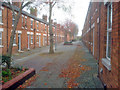
7
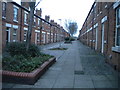
Princes Street, Eastwood
One of a group of streets known locally as "the squares" this now pedestrianised street of terraced houses was built by the local colliery company in the 1850s. DH Lawrence's home was nearby Image and he later described the houses as "sordid and hideous". They look very clean and smart today.
Image: © Graham Hogg
Taken: 13 Dec 2021
0.05 miles
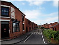
8
Princes Street, Eastwood (2)
A pedestrianised residential street on the northern edge of the town centre.
Image: © Richard Vince
Taken: 24 Nov 2018
0.05 miles
9
UK Street Sign
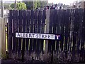
UK Street Sign On Albert Street Eastwood Nottingham Nottinghamshire.
Image: © gary
Taken: 26 Aug 2019
0.05 miles
10
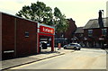
Eastwood, Albert St - NG16
A plaque on the side wall of this frozen food retail store at the junction of Albert Street and Nottingham Road flags up the fact that the Congregational Church that the Lawrence's once worshipped at stood on this spot. D.H. Lawrence's mother, Lydia, was a keen attender who sought to improve her spiritual and social life, and her children's, through her participation at it. Her husband, "a butty man" (an independent foreman miner, who led a small team of miners who worked for him) didn't aspire to the same dizzy heights and there was apparently a great deal of friction between husband and wife. There is a suggestion that they became less and less compatible and that Lydia tried to turn the children against their father. D.H. Lawrence certainly seems to have abandoned any religious convictions in his teens.
Image: © David Hallam-Jones
Taken: 7 Sep 2012
0.06 miles