IMAGES TAKEN NEAR TO
Byron Crescent, NOTTINGHAM, NG16 2SX
Introduction
This page details the photographs taken nearby to Byron Crescent, NG16 2SX by members of the Geograph project.
The Geograph project started in 2005 with the aim of publishing, organising and preserving representative images for every square kilometre of Great Britain, Ireland and the Isle of Man.

There are currently over 7.5m images from over14,400 individuals and you can help contribute to the project by visiting https://www.geograph.org.uk
Image Map
Images are licensed for reuse under creativecommons.org/licenses/by-sa/2.0
Notes
- Clicking on the map will re-center to the selected point.
- The higher the marker number, the further away the image location is from the centre of the postcode.
Image Listing (39 Images Found)
Images are licensed for reuse under creativecommons.org/licenses/by-sa/2.0
Image
Details
Distance
3
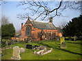
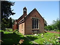
St Peter's Church, Awsworth
The Church of England establishment in the village.
Image: © Richard Vince
Taken: 11 Mar 2016
0.09 miles
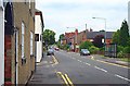
4
The Lane, Awsworth
Just beyond here The Lane becomes Main Street and heads down the hill towards Kimberley. Note the IKEA store at Giltbrook Retail park in the distance.
Image: © Stephen McKay
Taken: 2 Jan 2012
0.09 miles
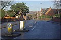
5
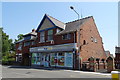
Convenience store and Post Office on The Lane, Awsworth
Showing position of Postbox No. NG16 40.
See Image] for postbox.
Image: © JThomas
Taken: 29 Jun 2019
0.09 miles
6
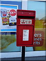
Elizabeth II postbox on The Lane, Awsworth
Outside the Post Office.
Postbox No. NG16 40.
See Image] for context.
Image: © JThomas
Taken: 29 Jun 2019
0.09 miles
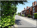
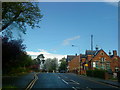
10
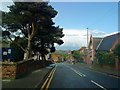
Awsworth
Until the construction of the bypass, this was a very busy road through the village leading from Ilkeston to the M1 motorway. The building centre right is the Methodist Church.
Image: © Garth Newton
Taken: 28 Jun 2003
0.11 miles