IMAGES TAKEN NEAR TO
Grange Estate, NOTTINGHAM, NG16 2SL
Introduction
This page details the photographs taken nearby to Grange Estate, NG16 2SL by members of the Geograph project.
The Geograph project started in 2005 with the aim of publishing, organising and preserving representative images for every square kilometre of Great Britain, Ireland and the Isle of Man.

There are currently over 7.5m images from over14,400 individuals and you can help contribute to the project by visiting https://www.geograph.org.uk
Image Map
Images are licensed for reuse under creativecommons.org/licenses/by-sa/2.0
Notes
- Clicking on the map will re-center to the selected point.
- The higher the marker number, the further away the image location is from the centre of the postcode.
Image Listing (27 Images Found)
Images are licensed for reuse under creativecommons.org/licenses/by-sa/2.0
Image
Details
Distance
1

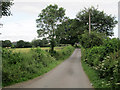
Cossall: Robinettes Lane in autumn
Further on, the lane becomes a bridle way and leads to Strelley, on the western edge of Nottingham.
Image: © John Sutton
Taken: 2 Nov 2016
0.03 miles
2
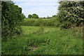
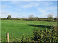
At the end of the footpath
Looking across farmland at the end of the accessible part of the Robbinetts Arm.
Image: © Kate Jewell
Taken: 12 May 2008
0.11 miles
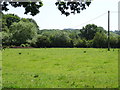
3

Cossall: a field of cattle
Looking from Robinettes Lane towards Brickyard Plantation and Oldmoor Wood on a bright morning in early November.
Image: © John Sutton
Taken: 2 Nov 2016
0.11 miles
5
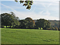
Cossall: over the hedge from Robinettes Lane
The picture was taken on a bright November morning. Oldmoor Wood is in the distance.
Image: © John Sutton
Taken: 2 Nov 2016
0.12 miles
7
Towards Cossall on Robinettes Lane
The rooftops of Ilkeston, on the Derbyshire side of the Erewash, show on the skyline to the left.
Image: © John Sutton
Taken: 16 Jun 2014
0.13 miles
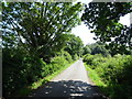
8

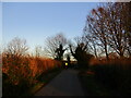
Cossall: a November morning on Robinettes Lane
The lane leads on, as a bridle way, to Strelley on the western edge of Nottingham.
Image: © John Sutton
Taken: 2 Nov 2016
0.13 miles
10
Over the hedge on Robinettes Lane
Looking north-west towards Spring Wood and, on the skyline to the left of centre, Swingate Water Tower and the wind turbine at Swingate Farm, both a mile or so away.
Image: © John Sutton
Taken: 14 Oct 2017
0.20 miles