IMAGES TAKEN NEAR TO
Main Street, NOTTINGHAM, NG16 2QT
Introduction
This page details the photographs taken nearby to Main Street, NG16 2QT by members of the Geograph project.
The Geograph project started in 2005 with the aim of publishing, organising and preserving representative images for every square kilometre of Great Britain, Ireland and the Isle of Man.

There are currently over 7.5m images from over14,400 individuals and you can help contribute to the project by visiting https://www.geograph.org.uk
Image Map
Images are licensed for reuse under creativecommons.org/licenses/by-sa/2.0
Notes
- Clicking on the map will re-center to the selected point.
- The higher the marker number, the further away the image location is from the centre of the postcode.
Image Listing (35 Images Found)
Images are licensed for reuse under creativecommons.org/licenses/by-sa/2.0
Image
Details
Distance
5
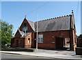
Former school on Main Street, Awsworth
Inscription above the door reads "Awsworth Board Schools 1878".
Image: © JThomas
Taken: 29 Jun 2019
0.06 miles
7
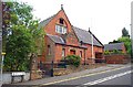
Old School Building, Main St, Awsworth
The inscription above the door reads "Awsworth Board School 1878"
Image: © Garth Newton
Taken: 28 Jun 2003
0.07 miles
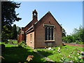
9
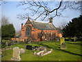
St Peter's Church, Awsworth
The Church of England establishment in the village.
Image: © Richard Vince
Taken: 11 Mar 2016
0.07 miles
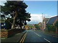
10
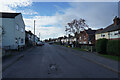
Station Road
Though it is called Station Road there does not appear to be any station nearby.
Image: © Malcolm Neal
Taken: 18 Nov 2021
0.08 miles