IMAGES TAKEN NEAR TO
Newdigate Street, NOTTINGHAM, NG16 2NJ
Introduction
This page details the photographs taken nearby to Newdigate Street, NG16 2NJ by members of the Geograph project.
The Geograph project started in 2005 with the aim of publishing, organising and preserving representative images for every square kilometre of Great Britain, Ireland and the Isle of Man.

There are currently over 7.5m images from over14,400 individuals and you can help contribute to the project by visiting https://www.geograph.org.uk
Image Map
Images are licensed for reuse under creativecommons.org/licenses/by-sa/2.0
Notes
- Clicking on the map will re-center to the selected point.
- The higher the marker number, the further away the image location is from the centre of the postcode.
Image Listing (65 Images Found)
Images are licensed for reuse under creativecommons.org/licenses/by-sa/2.0
Image
Details
Distance
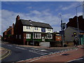
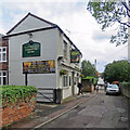
1
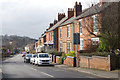
Newdigate Street, Kimberley
Looking down Newdigate Street towards Kimberley's town centre.
Image: © Stephen McKay
Taken: 11 Mar 2018
0.03 miles
2
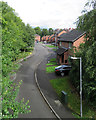
Kimberley: once the goods yard
This street is The Sidings, built on where the goods yard of Kimberley East station once was. A large wooden goods shed survived for a number of years after the Nottingham Victoria to Derby Friargate line closed (to passengers on 7 September 1964 and to goods on 2 November of that year). The line was built by the Great Northern Railway in the 1870s, chiefly to serve the Nottinghamshire and Derbyshire collieries. The view is from the footbridge (now renewed) which crossed the railway.
Image: © John Sutton
Taken: 8 Sep 2017
0.06 miles
3
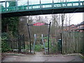
Great Northern Railway Path
A short path following the former route of the Great Northern Railway. (Not to be confused with the Great Northern Railway Trail - a Sustrans project further north). The flyover pedestrian bridge connects residential areas on Edgwood Road and Newdigate Street.
Image: © Tim Heaton
Taken: 29 Dec 2008
0.07 miles
4
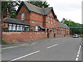
Great Northern Railway Kimberley Station
This is one of two stations that Kimberley had. The other station was owned by the Midland railway and is close by.
Image: © Neil Robinson
Taken: 23 Jul 2010
0.08 miles
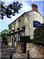
5
Gate Inn, Kimberley
Now serving so called Kimberley Ales from Suffolk rather than the nearby Hardy and Hansons Kimberley brewery, recently closed, following its acquisition by Greene King accountants.
Image: © al partington
Taken: 17 Aug 2007
0.08 miles
6
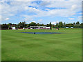
Kimberley Institute Cricket Ground
The square was covered ahead of a match the following day. The mowing patterns give an idea of how steeply the outfield slopes down from the pavilion - the most distinctive feature of the ground. Kimberley Institute is one of the most successful clubs in the Nottinghamshire Premier League.
Image: © John Sutton
Taken: 8 Sep 2017
0.08 miles
7
Cricketers Rest, Kimberley
Now serving so called Kimberley Ales from Suffolk rather than the adjacent old Victorian, Hardy and Hansons brewery. Makes a lot of sense.
Image: © al partington
Taken: 17 Aug 2007
0.09 miles
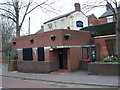
8
Kimberley: support for England at the World Cup
The Gate Inn on Main Street. England had just qualified for the knock-out stages of the 2018 World Cup in Russia.
Image: © John Sutton
Taken: 26 Jun 2018
0.10 miles
9
Kimberley: the Cricketers' Rest
Beer is no longer brewed in Kimberley, alas, but Nottingham Brewery Co provides a local ale at this pub - not far from Image] as it happens. (The English teacher in me has restored the apostrophe missing from the sign.)
Image: © John Sutton
Taken: 8 Sep 2017
0.10 miles
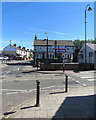
10
Public conveniences, Main Street, Kimberley
Closed for renovation.
Image: © Tim Heaton
Taken: 29 Dec 2008
0.10 miles