IMAGES TAKEN NEAR TO
Main Street, NOTTINGHAM, NG16 2NG
Introduction
This page details the photographs taken nearby to Main Street, NG16 2NG by members of the Geograph project.
The Geograph project started in 2005 with the aim of publishing, organising and preserving representative images for every square kilometre of Great Britain, Ireland and the Isle of Man.

There are currently over 7.5m images from over14,400 individuals and you can help contribute to the project by visiting https://www.geograph.org.uk
Image Map
Images are licensed for reuse under creativecommons.org/licenses/by-sa/2.0
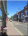
Notes
- Clicking on the map will re-center to the selected point.
- The higher the marker number, the further away the image location is from the centre of the postcode.
Image Listing (65 Images Found)
Images are licensed for reuse under creativecommons.org/licenses/by-sa/2.0
Image
Details
Distance
1

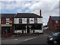
Britain's new church?
The irony of licensed premises (Dillinger's Bar and Diner) occupying a former chapel - which probably taught temperance - is compounded by the new stained glass windows which show people drinking at a bar!
Image: © Tim Heaton
Taken: 29 Dec 2008
0.01 miles
3
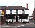
Lord Clyde
Public House. Main Street, Kimberley, Nottinghamshire
Image: © Alf Beard
Taken: 2 May 2014
0.01 miles
4

Kimberley War Memorial
https://www.iwm.org.uk/memorials/item/memorial/59089
Image: © Graham Hogg
Taken: 14 Mar 2022
0.02 miles
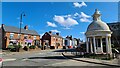
6

Kimberley: War Memorial and Sainsbury's
The War Memorial clock was a few minutes fast on a sultry July evening. For more about the memorial, dedicated in 1921, see http://www.iwm.org.uk/memorials/item/memorial/59089 .
Image: © John Sutton
Taken: 19 Jul 2016
0.03 miles
7
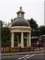
Kimberley War Memorial
Now incongruously standing outside the entrance to a supermarket.
Image: © Oxymoron
Taken: 30 Aug 2008
0.03 miles
8
Kimberley: Main Street
Before the A610 bypass was built this was the main road from Nottingham to Ripley and on to the Peak District.
Image: © John Sutton
Taken: 26 Jun 2018
0.04 miles

10

Across Kimberley Cricket Ground
The square was covered ahead of a match the following day. The mowing patterns give an idea of how steeply the outfield slopes down from the pavilion - the most distinctive feature of the ground (and perhaps shown more clearly in Image]). Kimberley Institute CC is one of the most successful clubs in the Nottinghamshire Premier League.
Kimberley Cemetery shows on the skyline just to the right of centre.
Image: © John Sutton
Taken: 8 Sep 2017
0.07 miles