IMAGES TAKEN NEAR TO
Glenfield Avenue, NOTTINGHAM, NG16 2HB
Introduction
This page details the photographs taken nearby to Glenfield Avenue, NG16 2HB by members of the Geograph project.
The Geograph project started in 2005 with the aim of publishing, organising and preserving representative images for every square kilometre of Great Britain, Ireland and the Isle of Man.

There are currently over 7.5m images from over14,400 individuals and you can help contribute to the project by visiting https://www.geograph.org.uk
Image Map
Images are licensed for reuse under creativecommons.org/licenses/by-sa/2.0
Notes
- Clicking on the map will re-center to the selected point.
- The higher the marker number, the further away the image location is from the centre of the postcode.
Image Listing (13 Images Found)
Images are licensed for reuse under creativecommons.org/licenses/by-sa/2.0
Image
Details
Distance
1
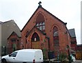
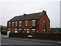
Methodist Chapel ("The Red Chapel"), Truman Street, Kimberley
Saved from demolition by the Greasley and District Civic Society. See http://www.eastmidcivicsocieties.org.uk/index.php?option=com_docman&task=doc_view&gid=1
Image: © Tim Heaton
Taken: 28 Dec 2008
0.06 miles
2
Gilthill Primary School, Kimberley
Apparently this was built in 1893, although the bricks on the facade look new and completely unweathered.
Image: © Oxymoron
Taken: 30 Aug 2008
0.07 miles
3
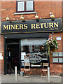
Miners Return, Kimberley
There can be few areas of the country so rich in micropubs as here along the old road from Nottingham to Heanor. One of them is the Miners Return sandwiched between a convenience store and a fish and chip shop on Eastwood Road at Kimberley. This was the site of Kimberley Miners' Welfare (a social club) and the mining heritage is acknowledged in the name of the pub.
Image: © Stephen McKay
Taken: 3 Sep 2022
0.09 miles
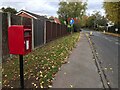
5
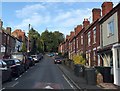
Maws Lane in Kimberley
Viewed from a spot close to the junction with Eastwood Road. A slightly dubious personal honour is attached to this picture as it's the first time in 12 years of Geographing that I have been approached by a member of the public and asked why I was taking a photograph. There were no hassles to report on this occasion.
Image: © Jonathan Clitheroe
Taken: 16 Oct 2019
0.12 miles
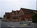
6
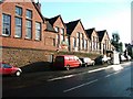
Gilthill Primary School
Formerly the Greasley Board School, built in 1893.
Image: © Mick Garratt
Taken: 21 Feb 2006
0.12 miles
7
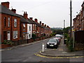
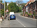
Maws Lane, Kimberley
Looking down towards Eastwood Road.
Image: © Oxymoron
Taken: 30 Aug 2008
0.13 miles
9
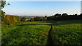
On the Robin Hood Way northwest of Kimberley
Image: © Colin Park
Taken: 8 Sep 2021
0.16 miles