IMAGES TAKEN NEAR TO
Cider Orchard Place, NOTTINGHAM, NG16 2GL
Introduction
This page details the photographs taken nearby to Cider Orchard Place, NG16 2GL by members of the Geograph project.
The Geograph project started in 2005 with the aim of publishing, organising and preserving representative images for every square kilometre of Great Britain, Ireland and the Isle of Man.

There are currently over 7.5m images from over14,400 individuals and you can help contribute to the project by visiting https://www.geograph.org.uk
Image Map
Images are licensed for reuse under creativecommons.org/licenses/by-sa/2.0
Notes
- Clicking on the map will re-center to the selected point.
- The higher the marker number, the further away the image location is from the centre of the postcode.
Image Listing (64 Images Found)
Images are licensed for reuse under creativecommons.org/licenses/by-sa/2.0
Image
Details
Distance
1
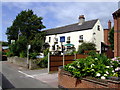
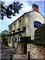
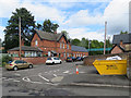
Nelson and Railway, Kimberley
Often considered the brewery tap of the nearby Hardy and Hanson Victorian brewery. Acquired by Greene King last year whose moneymen promptly consigned a perfectly viable brewery and their Kimbereley Ales to history. The pub still worth visiting though.
Image: © al partington
Taken: 17 Aug 2007
0.06 miles
2
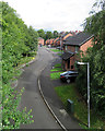
Kimberley: once the goods yard
This street is The Sidings, built on where the goods yard of Kimberley East station once was. A large wooden goods shed survived for a number of years after the Nottingham Victoria to Derby Friargate line closed (to passengers on 7 September 1964 and to goods on 2 November of that year). The line was built by the Great Northern Railway in the 1870s, chiefly to serve the Nottinghamshire and Derbyshire collieries. The view is from the footbridge (now renewed) which crossed the railway.
Image: © John Sutton
Taken: 8 Sep 2017
0.06 miles
3
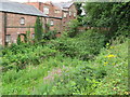
Midland Railway route entering Kimberley
In the background of the image is part of the disused Hardys and Hansons brewery. The remains of a platform is just visible. There is also a bridge that goes over the old railway line that carries a road (Hardy Street). The other side of the bridge is the Midland railway Kimberley station.
Image: © Neil Robinson
Taken: 23 Jul 2010
0.07 miles
4
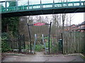
Great Northern Railway Path
A short path following the former route of the Great Northern Railway. (Not to be confused with the Great Northern Railway Trail - a Sustrans project further north). The flyover pedestrian bridge connects residential areas on Edgwood Road and Newdigate Street.
Image: © Tim Heaton
Taken: 29 Dec 2008
0.07 miles
5
Cricketers Rest, Kimberley
Now serving so called Kimberley Ales from Suffolk rather than the adjacent old Victorian, Hardy and Hansons brewery. Makes a lot of sense.
Image: © al partington
Taken: 17 Aug 2007
0.07 miles
6
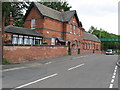
Great Northern Railway Kimberley Station
This is one of two stations that Kimberley had. The other station was owned by the Midland railway and is close by.
Image: © Neil Robinson
Taken: 23 Jul 2010
0.07 miles
7
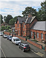
Kimberley: once the Great Northern railway station
The cars are parked in what was the station forecourt. The platforms were on the other side of the building. The view is from the footbridge - for a ground-level view see Image
Now houses, Kimberley is the same style as the other stations on the Great Northern Railway Derbyshire Extension line built in the 1870s, principally to carry coal. Passenger services were from the Pinxton branch and Derby Friargate to Nottingham (originally London Road and later Victoria). The Pinxton line closed in January 1963, and as a sixth-former I was on the last train from Friargate to the Vic on 7 September 1964.
Other Derbyshire Lines stations:
Image]
Image]
Image]
Image]
Image]
Image: © John Sutton
Taken: 8 Sep 2017
0.08 miles
8
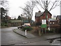
Kimberley (East) railway station (site), Nottinghamshire
Opened in 1876 as Kimberley by the Great Northern Railway on the line from Nottingham to Derby Friargate, this station closed in 1964. It had been renamed Kimberley East in 1955.
View north east over the former level crossing towards Basford North and Nottingham.
Image: © Nigel Thompson
Taken: 22 Jan 2016
0.08 miles
9
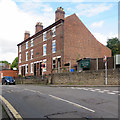
Kimberley: Clinton Terrace
An austere row on Nine Corners, at the junction with Station Road (right).
Image: © John Sutton
Taken: 8 Sep 2017
0.08 miles
10
Kimberley: the former Great Northern Railway station
Now houses, this building is the same style as the others on the Great Northern Railway Derbyshire Extension line built in the 1870s, principally to carry coal. Passenger services were from the Pinxton branch and Derby Friargate to Nottingham (originally London Road and later Victoria). The Pinxton line closed in January 1963, and as a sixth-former I was on the last train from Friargate to the Vic on 7 September 1964.
Other Derbyshire Lines stations:
Image]
Image]
Image]
Image]
Image]
Image: © John Sutton
Taken: 8 Sep 2017
0.08 miles