IMAGES TAKEN NEAR TO
Moorgreen, NOTTINGHAM, NG16 2FD
Introduction
This page details the photographs taken nearby to Moorgreen, NG16 2FD by members of the Geograph project.
The Geograph project started in 2005 with the aim of publishing, organising and preserving representative images for every square kilometre of Great Britain, Ireland and the Isle of Man.

There are currently over 7.5m images from over14,400 individuals and you can help contribute to the project by visiting https://www.geograph.org.uk
Image Map
Images are licensed for reuse under creativecommons.org/licenses/by-sa/2.0
Notes
- Clicking on the map will re-center to the selected point.
- The higher the marker number, the further away the image location is from the centre of the postcode.
Image Listing (26 Images Found)
Images are licensed for reuse under creativecommons.org/licenses/by-sa/2.0
Image
Details
Distance
1
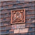
Date plaque, 52 & 54 Moorgreen, Greasley
Terracotta plaque carrying the coronet and initial of Lord Cowper. See http://www.geograph.org.uk/photo/5967326 for location.
Image: © Alan Murray-Rust
Taken: 2 Nov 2018
0.02 miles
2
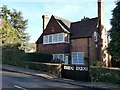
52 & 54 Moorgreen, Greasley
A pair of estate cottages, by E. W. Godwin for Earl Cowper of Beauvale, dated 1875. The design with its large expanses of window and tile-hanging is remarkably modern for its date. Listed Grade II.
The left hand of the pair has a remarkable set of garden gates http://www.geograph.org.uk/photo/5967333 , only partly visible in this picture.
Image: © Alan Murray-Rust
Taken: 2 Nov 2018
0.02 miles
3
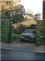
Gates at 52 Moorgreen, Greasley
These are rather out of place for a relatively humble dwelling http://www.geograph.org.uk/photo/5967326 , but are of historical interest. They date from 1709 and were originally installed at Collins' Almshouses at Friar Lane in Nottingham http://www.abelcollins.org.uk/history.htm , and were moved here in 1973.
Image: © Alan Murray-Rust
Taken: 2 Nov 2018
0.03 miles
4
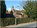
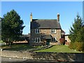
31 Moorgreen, Greasley
Early 19th century farmhouse, altered c.1875 by E. W. Godwin for Earl Cowper. Listed Grade II.
Image: © Alan Murray-Rust
Taken: 2 Nov 2018
0.03 miles
5
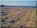
Hay field near Moorgreen
Looking west across a field ready for baling, probably quite a relief to the farmer this late in the year.
Image: © Trevor Rickard
Taken: 10 Sep 2009
0.11 miles
6
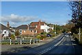
B6010, Moorgreen at Greasley
The housing is mainly 20th century ribbon development, with just a few older houses.
The road takes its name from the local settlement of Moorgreen.
Image: © Alan Murray-Rust
Taken: 2 Nov 2018
0.11 miles
7
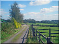
Track at Moorgreen
Looking east towards Greasley Church.
Image: © Trevor Rickard
Taken: 10 Sep 2009
0.16 miles
8
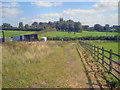
Path through stables at Moorgreen
Looking east to Greasley church tower. Stables on the left and exercise track just ahead in front of the hedge.
Image: © Trevor Rickard
Taken: 10 Sep 2009
0.18 miles
9
Poplar Farmhouse, Moor Green
Mid 18th century, one of the pre-industrial buildings of Moor Green. Listed Grade II.
Image: © Alan Murray-Rust
Taken: 2 Nov 2018
0.18 miles
10
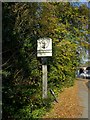
Moorgreen village sign
The picture represents the headgear of the local colliery, which was the last in the neighbourhood to close, in 1985.
Image: © Alan Murray-Rust
Taken: 2 Nov 2018
0.18 miles