IMAGES TAKEN NEAR TO
Main Street, NOTTINGHAM, NG16 2EU
Introduction
This page details the photographs taken nearby to Main Street, NG16 2EU by members of the Geograph project.
The Geograph project started in 2005 with the aim of publishing, organising and preserving representative images for every square kilometre of Great Britain, Ireland and the Isle of Man.

There are currently over 7.5m images from over14,400 individuals and you can help contribute to the project by visiting https://www.geograph.org.uk
Image Map
Images are licensed for reuse under creativecommons.org/licenses/by-sa/2.0
Notes
- Clicking on the map will re-center to the selected point.
- The higher the marker number, the further away the image location is from the centre of the postcode.
Image Listing (26 Images Found)
Images are licensed for reuse under creativecommons.org/licenses/by-sa/2.0
Image
Details
Distance
1
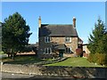
Poplar Farmhouse, Moor Green
Mid 18th century, one of the pre-industrial buildings of Moor Green. Listed Grade II.
Image: © Alan Murray-Rust
Taken: 2 Nov 2018
0.16 miles
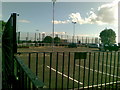
3
The Dovecote, Beauvale
Deserted public house. Given its current condition, it would not be surprising to find it actually occupied by pigeons!
Image: © Alan Murray-Rust
Taken: 2 Nov 2018
0.20 miles
4
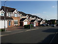
Modern houses, Salcombe Close, Newthorpe
Image: © Tim Heaton
Taken: 23 May 2009
0.20 miles
5
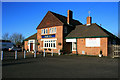
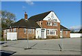
Ram Inn
Beauvale.
With all Hardy Hanson signage gone.
Image: © David Lally
Taken: 6 Dec 2008
0.20 miles
6
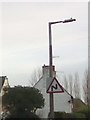
UK Double Bend From The Right Ahead Sign
UK Double Bend From The Right Ahead Sign on Beauvale, Newthorpe, Nottingham Nottinghamshire.
Image: © gary
Taken: 2 Feb 2016
0.21 miles
8
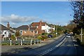
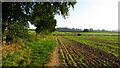
B6010, Moorgreen at Greasley
The housing is mainly 20th century ribbon development, with just a few older houses.
The road takes its name from the local settlement of Moorgreen.
Image: © Alan Murray-Rust
Taken: 2 Nov 2018
0.22 miles
9
Robin Hood Way leading northeast towards Greasley
Image: © Colin Park
Taken: 8 Sep 2021
0.22 miles
10
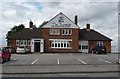
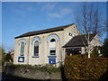
The Ram Inn (renamed)
Recently been reopened and renamed The Dovecote.
Image: © Neil Packwood
Taken: 17 Jul 2010
0.22 miles