IMAGES TAKEN NEAR TO
Briar Road, NOTTINGHAM, NG16 2BN
Introduction
This page details the photographs taken nearby to Briar Road, NG16 2BN by members of the Geograph project.
The Geograph project started in 2005 with the aim of publishing, organising and preserving representative images for every square kilometre of Great Britain, Ireland and the Isle of Man.

There are currently over 7.5m images from over14,400 individuals and you can help contribute to the project by visiting https://www.geograph.org.uk
Image Map
Images are licensed for reuse under creativecommons.org/licenses/by-sa/2.0
Notes
- Clicking on the map will re-center to the selected point.
- The higher the marker number, the further away the image location is from the centre of the postcode.
Image Listing (7 Images Found)
Images are licensed for reuse under creativecommons.org/licenses/by-sa/2.0
Image
Details
Distance
1

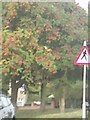
Footpath near Giltbrook Green
The notice is one of several warning against trespassing onto the land off the footpath, which is a public right of way.
Image: © Alan Murray-Rust
Taken: 2 Nov 2018
0.12 miles
2
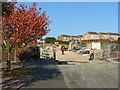
Acorn Avenue, Giltbrook
Housing development under construction on what was previously rather scrubby land will join the currently separated ends of Acorn Avenue.
Image: © Alan Murray-Rust
Taken: 2 Nov 2018
0.17 miles
3
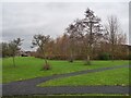
Smithurst Meadows
A local nature reserve in Giltbrook
Image: © Graham Hogg
Taken: 13 Dec 2021
0.21 miles
6
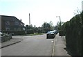
UK Pedestrian Crossing Ahead Sign
UK Pedestrian Crossing Ahead Sign on Nottingham Road, Eastwood, Nottingham Nottinghamshire.
Image: © gary
Taken: 3 Oct 2016
0.25 miles
7
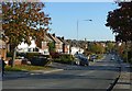
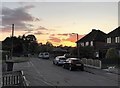
Nottingham Road, Newthorpe, Eastwood
Mainly inter-war housing on this section.
Originally the main A610 from Nottingham to Heanor and Ripley, now the B6010 following the construction of the Eastwood bypass.
Image: © Alan Murray-Rust
Taken: 2 Nov 2018
0.25 miles