IMAGES TAKEN NEAR TO
Newthorpe Common, NOTTINGHAM, NG16 2AW
Introduction
This page details the photographs taken nearby to Newthorpe Common, NG16 2AW by members of the Geograph project.
The Geograph project started in 2005 with the aim of publishing, organising and preserving representative images for every square kilometre of Great Britain, Ireland and the Isle of Man.

There are currently over 7.5m images from over14,400 individuals and you can help contribute to the project by visiting https://www.geograph.org.uk
Image Map
Images are licensed for reuse under creativecommons.org/licenses/by-sa/2.0
Notes
- Clicking on the map will re-center to the selected point.
- The higher the marker number, the further away the image location is from the centre of the postcode.
Image Listing (16 Images Found)
Images are licensed for reuse under creativecommons.org/licenses/by-sa/2.0
Image
Details
Distance
1
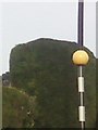
UK Zebra Crossing Pole
UK Zebra Crossing Pole on Nottingham Road, Giltbrook, Nottingham NG16 2GG, UK
Image: © gary
Taken: 3 Oct 2016
0.08 miles
2
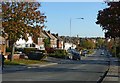
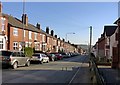
Nottingham Road, Newthorpe, Eastwood
Mainly inter-war housing on this section.
Originally the main A610 from Nottingham to Heanor and Ripley, now the B6010 following the construction of the Eastwood bypass.
Image: © Alan Murray-Rust
Taken: 2 Nov 2018
0.11 miles
3
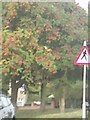
UK Pedestrian Crossing Ahead Sign
UK Pedestrian Crossing Ahead Sign on Nottingham Road, Eastwood, Nottingham Nottinghamshire.
Image: © gary
Taken: 3 Oct 2016
0.12 miles
4
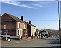
Nottingham Road below Hill Top, Eastwood
There is a benchmark http://www.geograph.org.uk/photo/5969036 on the pavement in front of the house with the bay windows.
Image: © Alan Murray-Rust
Taken: 2 Nov 2018
0.14 miles
5
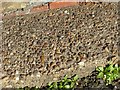
Rivet bench mark outside 309 Nottingham Road, Eastwood
See http://www.geograph.org.uk/photo/5969035 for location. An unusual spot for a rivet bench mark. The rivet remains in good condition although the bench mark arrow has disappeared completely due to the weathering of the concrete.
Image: © Alan Murray-Rust
Taken: 2 Nov 2018
0.14 miles
6
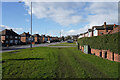
Nottingham Road
Looking along the Nottingham Road from the corner of Pinfold Road. The grass verbe is very wide at this point.
Image: © Malcolm Neal
Taken: 10 Feb 2022
0.16 miles
9
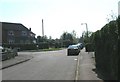
Nottingham Road below Hill Top, Eastwood
The narrowness of the road, particularly with residential parking, shows just how necessary the A610 bypass had become.
Image: © Alan Murray-Rust
Taken: 2 Nov 2018
0.20 miles
10
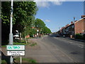
Entrance to Giltbrook ("A suburb of IKEA")
Originally a separate village, but now largely subsumed into an enlarged Eastwood. Though the website http://www.lawrenceseastwood.co.uk/Giltbrook/giltbrook.htm
refers to it as "A suburb of IKEA"
Image: © Tim Heaton
Taken: 23 May 2009
0.21 miles