IMAGES TAKEN NEAR TO
Holborn Close, NOTTINGHAM, NG16 1QZ
Introduction
This page details the photographs taken nearby to Holborn Close, NG16 1QZ by members of the Geograph project.
The Geograph project started in 2005 with the aim of publishing, organising and preserving representative images for every square kilometre of Great Britain, Ireland and the Isle of Man.

There are currently over 7.5m images from over14,400 individuals and you can help contribute to the project by visiting https://www.geograph.org.uk
Image Map
Images are licensed for reuse under creativecommons.org/licenses/by-sa/2.0
Notes
- Clicking on the map will re-center to the selected point.
- The higher the marker number, the further away the image location is from the centre of the postcode.
Image Listing (30 Images Found)
Images are licensed for reuse under creativecommons.org/licenses/by-sa/2.0
Image
Details
Distance
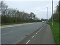
5
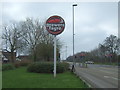
Brewers Fayre pub sign on Woodhouse Way (A6002)
For the Oldmoor Lodge public house, Nuthall.
Image: © JThomas
Taken: 27 Mar 2017
0.07 miles
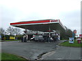
9
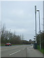
Communications mast on Woodhouse Way (A6002)
Looking north east.
Image: © JThomas
Taken: 27 Mar 2017
0.08 miles
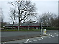
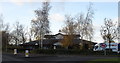
10
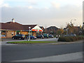
Assarts Farm Estate, Spar
This is the only retail outlet on this estate which because of the way it was developed relative to the Nottingham outer loop road is relatively isolated from main shopping.
Image: © Alan Murray-Rust
Taken: 4 Nov 2007
0.09 miles